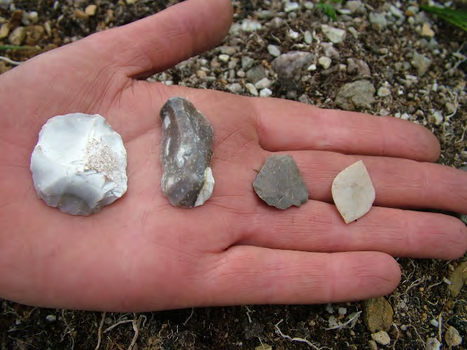
A new pdf report with a partial photographic presentation of the Howburn Farm Late Upper Palaeolithic and later prehistoric tool and lithic assemblage is now available to download.
Howburn Farm is currently a unique name in Scottish archaeology as having produced the only authenticated assemblage of Late Upper Palaeolithic (LUP) Hamburgian and Federmesser tools and debitage. The various publications on the site are given below as references and none of that is repeated here. This work simply presents in photographic form a selection of the gathered and excavated assemblage from a single field near the town of Biggar in South Lanarkshire. Photographs and their catalogues are given here for the benefit of researchers, but as the writer is not a specialist in lithic description or analyses, none will be attempted. The collection has however been published to academic standard by Torben Ballin whose work, along with other authors on Howburn Farm Project is cited below. At the time of writing the final destination of the assemblage is unknown but it is hoped that this work will allow others to access it in the form presented here, in pictorial form with its catalogue by Torben Ballin. This is however no substitute for the actual objects.
The kilns at Glencotho are however rather isolated but it is easy to see why they exist here, since the lime stone outcrop on the hill above was obviously quarried there, transported downhill on the track and used in the kilns.
An Excavation report on the lime clamp kilns at Glencotho, Peeblesshire, Scottish Borders in 2015. Download the full report from here.
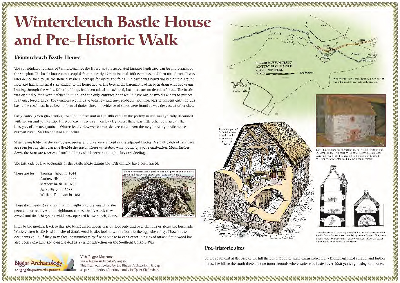
The excavated kiln is part of a group and was given in The Upper Tweed Archaeological Survey (Ward, 2004) (Pl 1): Site No 337 NT 02 NE NT 0873 2972 290m OD.
The kilns have been partially scooped and partially embanked. The reason for the limited excavation was to attempt to establish a link between the lime working and the nearby Chapelgill site (Ward, 2006) Chapelgill in Glenholm survey and excavation in 2013 where evidence of coal fired lime was used in the construction of walls and for plaster. The fact that the kilns exist in this particular and unusual location is due to the presence of the Wrae Limestone deposits which are rare occurrences of limestone in the Southern Uplands greywacke geology.
These objects were all found in Clydesdale apart from the lunulae (top left) which were discovered 1 mile from Biggar in Tweeddale, in the 19th century. They are all displayed in the Museum of Scotland in Edinburgh.
What is Treasure?
The Treasures of South Lanarkshire is an attempt by the author to highlight the almost unbelievable wealth of curated and built heritage of the area, and much of which is probably unknown to the general public, but all of which (and much more) is available to them. The present is indisputably the product of the past and while we leave our own legacy to the future it is incumbent on the current populations to ensure the past heritage in whatever form it takes, is preserved as much as is possible for the future.
Everything cannot be saved, however, it those special or rare objects, buildings and places which should easily be retained as material evidence of our rich history in South Lanarkshire. What is alarming however, are the sites and landscapes which have been destroyed and this reports highlights many which need not have been, they would now be considered as assets for their cultural and economic value. Often destroyed as acts of official vandalism, by people who simply have no empathy with heritage values or significance, the destruction continues to this day by people of unsympathetic values.
Each object or place has a story to tell, often part of that story is still unknown, which is all the more reason to preserve the hard evidence. The papers given here can only be seen as an introduction to selected parts of the overall story, hopefully to allow the reader to explore further in museums, libraries, towns, and the countryside and perhaps re-discover parts of that rich inheritance themselves. Obviously in a work such as this which can only briefly describe and illustrate the subject matter, omissions will occur, to reveal all would be a cyclopaedic task, but any places or objects not included here will undoubtedly be covered elsewhere in literature.
David Fisher painting – three panels of Clydesdale through the ages
By Tam Ward
David Fisher was born in Midsomer Norton in Somerset, he originally trained as a signwriter and decorator and gradually became a self employed artist. He was commissioned to paint pub signs all over England and produced a remarkable 400 of them over a fifteen year period. He also won a contract to paint the foyers of fourteen Trusthouse Forte motorway service areas between 1987 and 1993, and that is what brought him into my own life in Scotland.
One of his motorway service areas was at Abington Services on the newly constructed M74 through what was then Upper Clydesdale, now part of South Lanarkshire.
The theme for these paintings at each location was to represent local heritage sites and or significant events of historical interest. For inspiration he arrived at Biggar Museum to ask for advice on what was available. I remember first impressions of him as an extremely nice chap and after introductions I think he was quite astounded by what he learned next.
As it happened I was working from Biggar Museum on the M74 in the Abington area as the Archaeological Projects Officer, my function was to identify archaeological sites being disturbed by the new motorway and arrange for their excavation. The excavations were done by Glasgow University Archaeology Department and kick started their ‘commercial’ wing for archaeology, under Margaret Thatcher’s polices of making developers pay for this type of work, rather than the State through Universities and museums etc.
I was putting the finishing touches to my report which included an updated history section of the area which included the local archaeology, when in walked David Fisher.
He explained what his brief was at Abington and I could immediately see the potential in it all, what a glorious advertisement for our local story and it would be seen by countless thousands of motorway travellers for years to come. He asked the question, what could he paint about and had my report thrust into his hands with the statement “you could paint that”.
After I had taken him through most of the stories and features which were right on the doorstep of the new Services; all visible sites which, if one knew what they were, could easily be appreciated, and hopefully would inspire the viewer at Abington to make a stop over at Biggar Museum to gain even more of the experience of Clydesdale Heritage. Off David went with a copy of my report suitably highlighted with a range of possible stories which he could depict with his paint and brushes.
Some time later he sent pics of his preparatory paintings to the museum and asked if we approved, they were great and just what was needed to advertise our local heritage in a unique way in Clydesdale.
David then proceeded to produce the real thing at the Services foyer, they consisted of eight massive paintings on three walls, and when one walked through the entrance they were immediately visible, and it was simply unavoidable to miss them.
Fortunately, I photographed them and with David’s permission used the images regularly in talks and lectures. Later I asked if I could use the pictures in articles and reports as and when I needed them and his answer was “of course Tam, use them with my blessing”, and I have done so ever since and am exceedingly grateful because each one illustrates their topics so well.
However, nothing lasts forever, and now sadly all that remains at Abington Services foyer, now owned by Welcome Break, is a boring painted red area where once the beautiful, informative, and meaningful paintings once graced. The paintings were a real show stopper when one entered because you could not miss them, they were big and colourful and depicted various scenes from the past in the area, but in the minds of the new owners a boring wall looks better.
When Trusthouse Forte opened, I asked if they would like some display cases with objects from the museum to supplement the paintings, they readily agreed and for a while we had an outreach museum display in the restaurant there. Of course when the paintings were no longer wanted, neither were the display cases, now if you go to that establishment, be prepared to learn nothing about the locality, you may as well be in the south of England – somewhere!
I informed David about the sad demise of his work at Abington and know he was disappointed, but I did not realise that the same fate had befallen several other of his works at other service areas.
Anyway, his work is not gone, indeed it survives very well up here and I give images of his Abington murals, which if anyone wants copies of, then please contact me and I will oblige. What follows is the story behind the paintings, and a colourful story it is too.
David Fisher painting – three panels of Upper Clydesdale through the ages
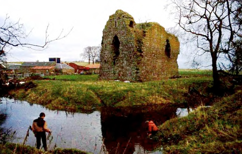
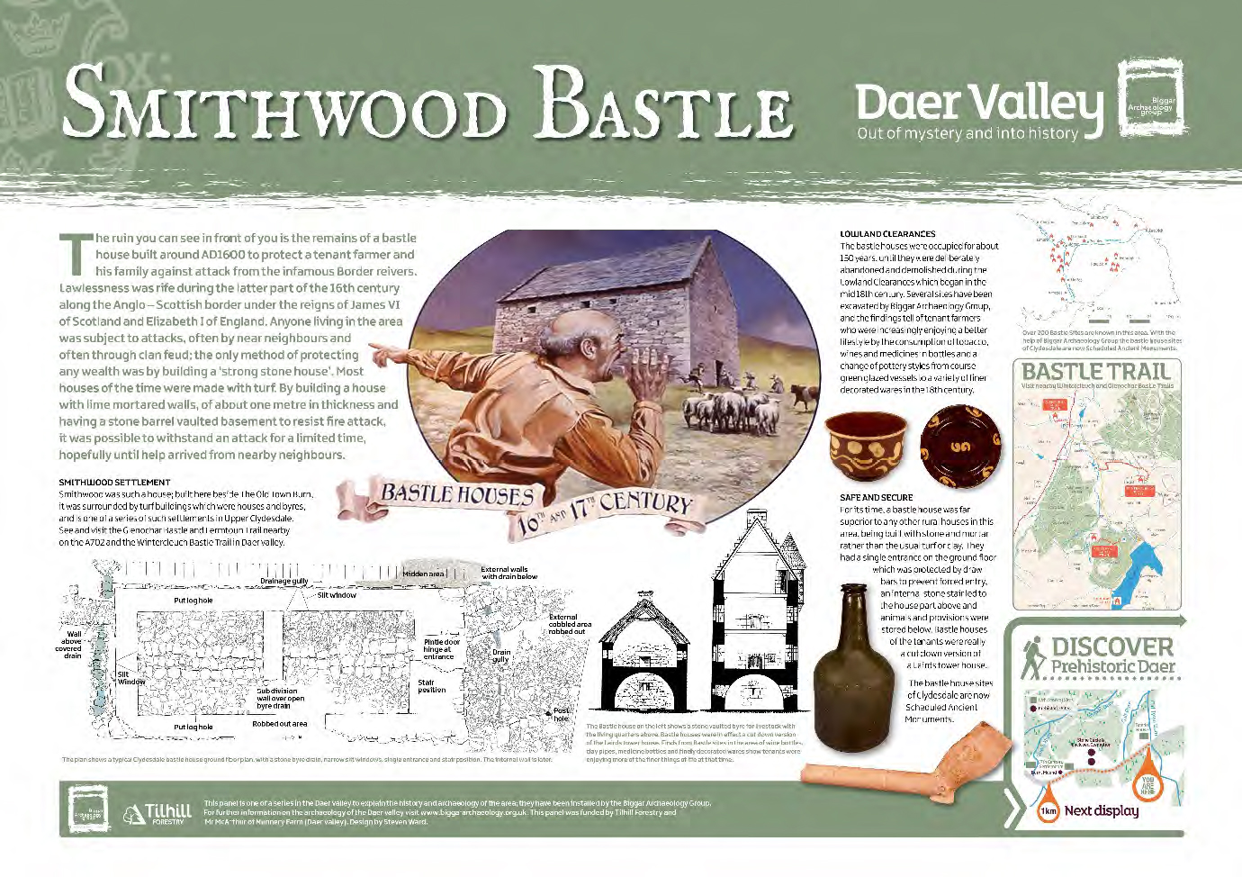
The first image was the centre piece in the mural facing the entrance, and we decided on the theme “Upper Clydesdale Through the Ages”. Bastle houses were first discovered far north of the Anglo-Scottish border by Biggar Archaeology Group (BAG) way back in 1986. A series of bastles were discovered in Upper Clydesdale and several were excavated by BAG and have been created into local heritage trails. Displays of models and artefacts from them can be seen in Biggar Museum.
Bastle houses are strong defensive buildings, in fact they were the last defensible houses to be built in Britain. They are cut down versions of a laird’s tower house and were often occupied by tenant farmers. Northumberland and Cumbria have always been well known for such buildings which were a direct response to the infamous ‘border reivers’ of the late 16th to early 17th centuries. BAG are the only organisation to have systematically surveyed, excavated and researched these buildings in Scotland, which are often erroneously referred to as ‘pele houses’.
Several so called ‘experts’ in the archaeological profession are seemingly averse to the name of ‘bastle house’, preferring the name ‘pele house’, but we believe we have made a good case for our nomenclature over theirs, and this and several reports on the subject can be viewed and downloaded on the BAG web site at www.biggararchaeology.org.uk where other reports deal with the remainder of David’s former Abington paintings.
Tinto Hill is shown on the image and which can be seen from Abington, is crowned by a gigantic burial cairn which may date back to the Neolithic period, it is sixty metres in diameter by 6m high! And can be seen from many parts of southern Scotland.
David Fisher painting of Bronze age village
Continuing but in chronological order we have the image of a Bronze Age village within two miles from Abington. The site is known as Lintshie Gutter and is part of a grouping of thirty five house platforms strung along the side of the hill at Crawford.
No where else in Britain is there such a proliferation of visible Bronze Age house sites, over 450 can be seen between the upper reaches of the rivers Clyde and neighbouring Tweed which is in in Borders Region. They are known as Unenclosed Platform Settlements (UPS) and were possibly the last undefended house sites in Scottish prehistory. What followed in the Iron Age are numerous spectacular hillforts which have their roots in the latter stages of the Bronze Age around 500BC when the climate changed from a drier and slightly warmer one to what we live in today, damper, and colder! As available farming land became scarcer, it seems that hostilities were prevalent among communities, requiring the need for defensive settlements.
Peculiarly, the UPS sites for the round timber framed and conical roofed houses, always with a porched entrance, were scooped from the sides of the hills to form strings of platforms which were unenclosed and therefore undefended (hence the name), field systems, burial cairns and burnt mounds are found between the house sites in equal profusion. We now know through excavation that these house types were in use throughout the Entire Bronze Age circa 4500 – 2500 years ago. See Upper Tweed Fruid Reservoir project pages for more on UPS.
The Iron Age following is known for its defensive settlements especially hillforts, and two spectacular examples of many in Upper Clydesdale and Tweeddale, can be seen at Abington, one is Arbory Hill and the other is at Black Hill. Both are multi period hillforts having deep ditches and ramparts, but also later massive stone walls built within to protect the round houses they enclosed. The hillforts are often assumed to have been in response to the Roman incursion into Scotland in the first century AD, however increasing evidence points to the fact that hillforts were well developed before the advent of the Romans in this part of the world. Nevertheless, we know that the Romans did have severe problems in subduing tribes in Northern Britain (Scotland) and the hillforts would have helped the locals resist to some extent.
David Fisher’s painting of Crawford Roman Fort
However, the Romans did come and did conquer all, because of their superior organisational skills and extremely well trained armies, they subjugated wherever they went, through bribery, or sheer brute strength, building straight roads through any landscape, building temporary camps and more permanent forts as they went. Again, Upper Clydesdale has an excellent representation of Roman sites, the invading armies march north through Nithsdale and Annandale and into the upper reaches of the Clyde, they even left us its name, as ‘Clota’. They marched along the Clyde to the Biggar area where all roads north, south, east, and west met from prehistoric times to the present. Crawford fort was excavated and shown to have been occupied three times, once under Governor Agricola and twice under Emperor Antonine. Most of the Roman objects from the area are in Glasgow museums, but Biggar has a good display of the period. David’s painting shows a model of Crawford Roman fort in Biggar Museum.
David Fisher’s painting – Abington Motte and Bailey 12th Century
Right beside the Abington Services area is the only example in Clydesdale of a motte and bailey castle, although there are other important mottes such as Lanark, a Royal castle, Biggar, the home of the first Sherriff of Lanarkshire, Baldwin The Fleming, and Carnwath where a magnificent ‘pudding bowl’ motte sits on the golf course, once the home of the Sommerville family. These were among the first castles to be built in Scotland during the 12th century and under the Patronage of King David I and his grandson Malcolm IV, shown in the painting. David (the king) invited the sons of the conquerors at the Battle of Hastings to come to Scotland and establish law and order for him, the first thing they had to do was build a castle to protect themselves and their followers from the locals who were not quite so keen on them. It is possible that the Abington site of which David (the artist) has painted a model in Biggar Museum, was built by one Albin [Albins town = Abington] who was related to John of Crawfordjohn, and who unusually left his name to the nearby settlement there.
David Fisher’s painting for Bastle Houses
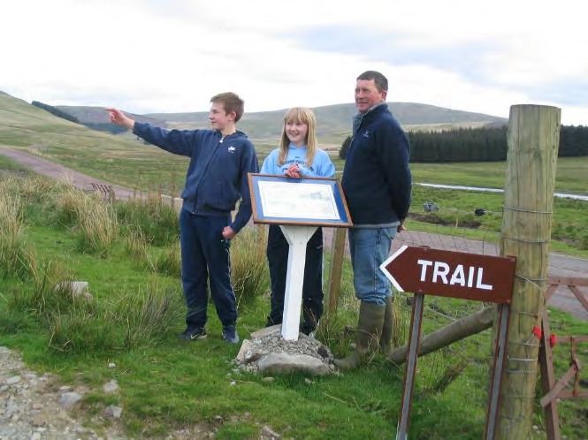
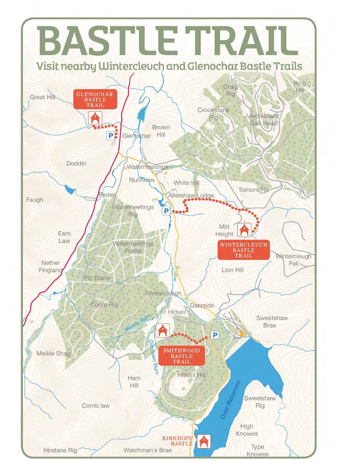
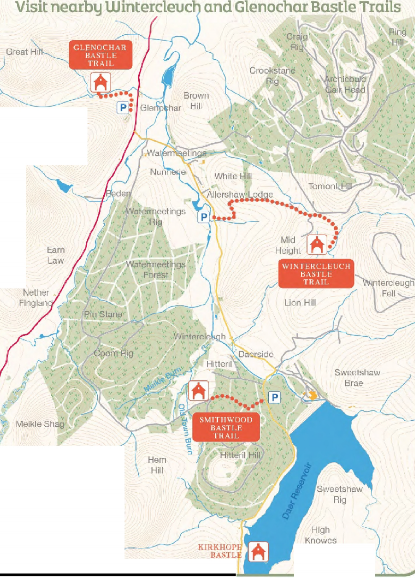
The next storyline in the former mural is of bastle houses and which are described above. However, BAG have now created several heritage trails to bastle house sites and a model of one is in Biggar Museum. The trails are at nearby Elvanfoot and Daer valley near the headwaters of the River Clyde. To visit these locations is to feel the atmosphere of the tenant farmers who strived to live off the seemingly barren hills with flocks of sheep and herds of cattle, the very things which attracted the Border reivers. The site at Glenochar was raided in 1600 and around 200 cattle were driven off. Tales of brutal murder and other atrocities are common during this disgraceful period of Anglo-Scottish history.
David Fisher painting – The Broken Bridge Mail Coach disaster
Before the coming of the railways in the early and mid-19th century, transport had been developing by roads. The Romans built the first roads through Clydesdale and these may still be seen in parts of the upland landscape. However as wider commerce increased across the country better roads and the means of travelling on them became necessary. In the 17th century there would be no wheeled transport in rural areas because there were no decent roads for such traffic to run on. It was horse back or foot for everybody. Better roads and bridges were required for example by the Hopetoun lead mining operations at Leadhills to get their lead to the port of Lieth for shipment to the Low Countries in the 17th century. Things began to improve with private trusts to build roads and, because many people were being drowned trying to cross rivers in flood, bridges were built often by local authorities, privately and by public subscription.
The first Royal Mail began running in Scotland between London and Glasgow in 1790 with stage coaches trundling along single track roads and bridges. The Great Road between London and Glasgow was a mere gravel track. It was another 36 years before Edinburgh had a similar service. The business is full of disaster stories of all sorts regarding the stage coaches everywhere in Britain, and Clydesdale has its very own – The Broken Bridge Mail Coach Disaster of 1808.
On a horrendously stormy night the north and south bound coaches should have met at a particular bridge south of Elvanfoot, near Beattock Summit. The south bound coach crashed over the collapsed bridge killing occupants and horses, however, one lady found herself stranded or a rock in the middle of the swollen river, screaming into the gale lashed night in forlorn hope of rescue. The north bound coach was arriving and but for the woman’s screams, would have joined them over the side of the broken bridge, they pulled up just in time.
During the rescue a young man attempted to save the stricken woman but afraid of the strict protocols of touching her, he shouted to his driver “Whaur wull ah grab her?”, the poor woman in instant peril of being washed away at the moment of salvation shouted back “Grab me where you will – but be sure to grab me firm”, what part of the woman’s anatomy was grabbed is not recorded, but she was saved. Thereafter the bridge was called The Broken Bridge.
Roads continued to be improved during the first half of the 19th century to speed the Royal Mail on its way and not to improve the lot of passengers in any form, they were simply an add on for extra revenue, but it was The Mail which was important. The great Thomas Telford was commissioned to improve the route south from Glasgow with better roads and bridges, some of the bridges still survive but most have been demolished (just like the paintings at Abington) by so called improvers with no sense of heritage in their bodies.
David Fisher’s painting depicting the Caledonian Railway
All seemed to be going well until literally at a stroke, the Royal Mail coaches were out of business along with most roads and bridges, because the new form of transport was the Caledonian Railway which came through Upper Clydesdale in 1847, completed by the famous bunch of navvies, many from Ireland.
During the construction in 1846 many navvies came across from Ireland to escape the Potato Famine only to succumb to typhus and cholera which was rife at that time. Thirty seven navvies are buried in a little graveyard beside the Clyde at the point where the old A74 road crosses. There once was an urban myth that the locals would not allow them to be buried in the old Crawford burial ground because they were Catholics and undesirables, but that is not true, the old church yard was already filled to capacity and that was the only reason they were eventually buried where they now lie. Later, the ground was consecrated by the Bishop of Glasgow, but not the Catholic one it was the Episcopalian Bishop.
The trains put the Royal Mail stage coaches out of business, now the Mail and the public could travel from London to Glasgow in a single day, in much greater comfort and safety, before that it could take two weeks “God permitting”! There were no outstanding feats of railway engineering in Upper Clydesdale as the track and bridges were fairly straight forward. However, to get over the Southern Uplands at Beattock Summit often two engines were required to push and pull the trains over the top. David’s painting includes ‘The Caledonian, Red Revolution on Beattock’, from an original painting by artist M A Turner 1985. The line was electrified in 1974 and now ultra-fast and silent trains run smoothly through Clydesdale, but not stopping anywhere apart from Carstairs where the original branch line to Edinburgh still operates. So it is that since the Mesolithic peoples of 10,000 years ago to the present, Upper Clydesdale has been the route in and out of south central Scotland. Firstly the river was used by hunter gatherers to find their way through, then the Romans built the first roads, followed by others down the centuries until the present M74 was constructed in 1992.
David Fisher’s painting of the M74
The final aspect of the former mural at Abington is the image of the newly constructed M74 Motorway between Abington and Crawford. Bringing the story right up to date at that time. The original route used by the Romans was improved to take stage coaches, then bettered by Thomas Telford. Only to be ruined by the railway, but then roads were resurrected by the demands of the next form of transport, cars, lorries, and buses. Once the A74 trunk road, it was rebuilt as a dual carriageway in the 1960’s and then upgraded to the road we use today, the M74, which, unfortunately whisks much of the traffic through the area cutting off its numerous attractions and incredible story of the past. All of the detail of this history is available in various BAG productions on this website.
David Fisher, artist – report on his Clydesdale legacy report is produced in memory of David Fisher and hopefully as a more lasting legacy of his contribution to our local heritage. The images are available from the writer if anyone wishes to have them, as David said, “the stories of the past belong to everyone and one way to provide them is through art”, never was a truer saying, so thank you.
In that article and the report we asked if anyone knew more to get in touch. We’d like to thank the Frame family for doing just that and sending through their family history which explains more of the story and man behind it – their great grandfather and a fuller version of the poem.
We’ve added it below, reproduced with their permission:
The man behind the wee war memorial in Elsrickle
James Bishop was good Christian man who worked his own market garden, “Oxengate”, in the centre of the village. On occasion, I believe he employed some “puirhoose bairns” to help in the busier times.
It was James Bishop, after the erection of the larger memorial outside the old kirk in Elsrickle who “couldnae staun to see in ony measure man’s inhumanity tae man.”
He approached the minister and, I believe, some of the Elders at the time, to have all those who left from the village for The Great War and never returned, to be honoured on the new monument.
The minister would not have these “in-comers” and “puirhoose bairns” on “his” monument.
In anger, James Bishop was heard to call the minister, “Nothing but a stentin’ post in hell” , a wonderful analogy for the leader of the local Kirk! (A Stenting Post is the strainer in a wire fence – the big posts that hold all the smaller posts (stobs) tight and secure).
From that day, James Bishop and his family never returned to The Kirk, but travelled the few miles to Walston Kirk by horse and cart every Sunday, rain, hail or shine. My father (Hugh Frame) remembered some miserable trips in the cart as a young boy being dragged along to Walston Kirk!
James found the money and used the little plot of land “Richt at the ither end o’ the street, the tapmaist and forebye” to erect the small monument with just the two names. It was he who decided on the the vital fact, “They also died for us”.
Some years later, James Bishop (grandson of James Bishop) was approached about another name of a fallen hero who was not recorded on any other monument (Sergeant Peter Clark R.A.S.C.). Following consultation with my father they gladly gave their blessing to have the 3rd name added as he had “also died for us”.
James Bishop was my great grandfather. His grand son, James Bishop (deceased), was a police officer who served with Salford City and Greater Manchester Police Forces retiring as a Detective Chief Inspector and has a family of 11 surviving children.
His Great Grandson, James Bishop Frame (my brother), was also a police officer who served with Lothian and Borders Police and the Police Service of Scotland and retired as a Superintendent in 2018.
Hugh Frame
New South Wales, Australia
The full version of the poem
The Twa Monuments
There’s a wee auld fashioned village
that lies aff the beaten track
And I want tae tell a story that ma
memory brings me back;
For in that wee auld village is a sicht
that’s quite unique.
For you’ll find a War Memorial at each
end o’the street.
In that wee auld fashioned village were
twa puirhoose bairns brocht up.
Twa laddies wha gied their labour for a
bed and bite and sup.
But when they grew to manhood the
Great War it broke oot
And wae a wheen o’ others they donned
the khaki cloot.
Frae oot that awfu carnage, were some
that ne’er came back
to the auld fashioned village, that
lies aff the beaten track.
No in the quite kirkyard their last
Resting place was found.
But far frae bonny Scotland they lie
in foreign ground.
In memory o’ thae gallant lads a
Monument was raised
On which their noble sacrifice commended
was and praised.
Their names were also written there
but sad it was tae see
nae mention o’ the puirhoose bairns –
Surely it couldnae be.
For they along wi’ ithers, had laid their
young lives doon.
And just the same as others deserved
fair Honour’s croon.
No muckle wealth nor gear had they,
but whit they had they gied.
Their very life’s bluid they poured oot
And for their country died.
The minister’s attention was drawn tae
the fact
but he just dismissed the matter and
quite refused tae act.
But in that wee auld village wis a man that
couldnae staun
to see in ony measure man’s
inhumanity tae man.
An’ sae tae richt the wrang that his
kindly hert felt sair.
A monument for their ain twa sels he
had erected there,
Richt at the ither end o’ the street, the
tapmaist and forebye
It stauns tae tell the story tae every
passerby.
The words engraved upon the stane are
plain and clearly tell
That it’s for “Twa Gallant Heroes” who
in the Great War fell.
And underneath their honoured names,
without display or fuss,
The vital fact it simply states
“They also died for us”.
Oh, may we, like that honest man, gie
honour whaur it’s due.
Esteeming character and truth – be pockets t’m or fu’.
Far aften in the humble cot true riches
they abound
When in the mansions o’ the rich they
scarcely can be found.
And let us think o’Anither Yin who
gied Himself for us
And ask ourselves the question “Whit dis it mean tae us?”
Sure it cannae be that we, wi cauld herts can despise
The Love Divine that bore our sins, in
Cavalry’s sacrifice,
But may we like that honest man with every word and act
Let oor lives be a memorial to that great and glorious fact.
Biggar Kirk, formerly known as St Mary’s Church is unique, being the last Pre-Reformation church to be built in Scotland. A fascinating history of the church dating back to the 12th century is available and some aspects of the building which have never been considered are given in Biggar Kirk Report. The church was dedicated to St Nicholas about 1399, became St Mary’s church, then was known as Biggar Kirk, it is now termed Biggar Parish Church and/or Biggar Kirk.
Biggar Kirk stain glass window No 13. Nave, north east. Legend.
Biggar Kirk is important in Scottish architectural and historical terms, both locally and nationally, and of fascinating interest for the visitor, whether taken as a brief or prolonged visit, the church and cemetery offer much to maintain attention. The church is instantly pictorial both inside and out; the interior with a full complement of beautiful stain glass windows offers a great deal to photographers and local historians alike, the exterior, no matter what season of the year, lends itself equally for the same reasons. If it can be arranged, the views from the battlemented tower are magnificent, overlooking much of the town and giving unfettered vistas of the surrounding hills. Few small Scottish towns can make such claims because most have churches of late 18th century or later dates, the time when Scottish Presbyterianism demanded plain buildings although concessions were made to stain glass window memorials. Nineteenth century churches with their lofty steeples and in some cases ornate architectural features broke the mould somewhat, but for an entire suite of reasons given above – Biggar Kirk takes a bit of beating.
Of particular significance are the features which allow the description ‘defended church’ to be applied. Built originally as a consequence of a murder, at a time of both religious and political turmoil, and with architectural characteristics normally found on defensive buildings to keep people out, and the fact it is the last Pre Reformation church to be built in Scotland, surely place this building in a special place of Scottish architecture and history.
It was hoped that the roof survey may have shown some Pre Reformation decoration, but none was found. However the survey has shown that the roof, although containing many original timbers has been subject to much alteration over the years and it is possible to state that it may well have been originally built “on the cheap” using second hand or inferior timber. Much new data has therefore been added to the story of this church, not the least the new list of mason’s marks around the walls. Further scrutiny of the building may no doubt add even more details than this paper has managed to do, for example the iconography of the stain glass windows and their artists. Such studies are rarely if ever complete, new information will come to light and new interpretations of such information may be put forward, hopefully this effort may kickstart further work at some time in the near or distant future.
Unfortunately, and because of a spate of vandalism, the church is now generally locked when not in use for services, but limited access may be available subject to voluntary attendants. For access, contact may be made at www.biggarkirk.btck.org.uk
The out of print report by Tam Ward on the survey work by the Biggar Archaeology Group as part of the M74 upgrade in Clydesdale, now South Lanarkshire, in 1990, it has now been digitised.
The fully indexed report consists of one hundred and sixteen survey plans with full descriptions, three chapters describing the project, the history of the area and a discussion of the sites included. Appendices cover the following:
Taped offset method of survey
Finds
Damage caused to unenclosed platform settlements
Wildshaw Burn Stone Circle, possible astronomical significance
Identification of a burnt mound
Other recent surveys in Clydesdale
Site types in Upper Clydesdale
Footnotes and references in text
Abbreviations
Since the survey was completed a vast amount of excavation, research and further survey work has been accomplished in the Upper Clyde valley, by both BAG in a voluntary capacity, and by others especially involved in development funded archaeology.
For example; BAG have completed major projects within reservoirs, commercial forests and in arable fields since this report was produced, significantly new discoveries and research has taken place by BAG, including aspects of the Late Upper Palaeolithic, Mesolithic, Neolithic and Bronze Age periods. All are reported on this site. Similarly, professional work on the Clyde Windfarm and other projects has also added significant knowledge of the ancient past to the local and national data bases.
Consequentially the archaeological story of the former area of Upper Clydesdale [now part of South Lanarkshire] has moved forward considerably. Nevertheless, the M74 report stands good for the comprehensive range of survey plans which remain an invaluable tool to students of the upland landscape there; it has not been updated due to the large quantity of work done in the last three decades and is merely reproduced here as a work of its time and place.
Plate 1. Tinto Hill as viewed from Lamington. Note the pink rock in the main body of the hill (felsite) and the black rock (basalt) protruding from a later intrusion.
A talk given by Tam Ward at Quothquan near Thankerton, some years ago.
History can be mystery and archaeology can be downright frustrating, often, literally, archaeology is rubbish! It’s all about trying to understand and learn about the past, neither of the disciplines is easy.
One would think that history should be the easier of the two since it deals with the written past or even more up to date events within living memory. That’s because we are fed selective bits of the story, and it depends who is telling it, whether we get the truth, half-truth or downright lies. Historians are just typical humans, they embellish the tale a little here and a little there, the same as we all do when telling a story, and we tell it the way we want to, perhaps to make it more dramatic, funnier, or to serve some more sinister purpose.
It can be even more complicated when researchers delve into the records, who produced the record in the first place – and why? is the researcher being thorough enough or a bit slip shod? are all the records there in the first place? and so it goes on.
A key word in all of this is “research”, literally going through data again by ‘re searching’, for the second, or numerous subsequent times, it’s easy to see how interpretations can change.
Archaeology depends on two things; people digging objects from the ground and then interpreting what they are and how they got there. The duty on the archaeologists is to retrieve all the information in the ground accurately and then preserve that information, be it an object, a soil sample or the record of what was there, this is often done in the form of photography and perhaps drawing. If a good record is made, then future researchers have a chance at working out what it all means, if the record is poor, then no one will ever be able to make sense of it, it’s the same with historical record.
So, there is a heavy burden of responsibility on the excavating archaeologist because they are providing the source information, the only available information on a site, and it can never be re-done. Then the fallibility kicks in when the archaeologist interprets what has been found, but if he or she gets it all wrong, at least others will have an opportunity to re interpret the evidence if it has been retrieved and recorded.
History and archaeology are not sciences such as chemistry, physics etc, where hypothesis can be tested and re-tested and proved one way or another. Historians and archaeologists therefore have a huge duty of responsibility to get the truth out of the evidence, in whatever form it becomes available.
This offering concerns a few local history myths around the town of Biggar, presenting the available evidence garnered from local sources, and some from further afield.
Tinto was never a volcano, but it was a mass of magma trying to be one. A volcano erupts on the surface of the planet, firing out a variety of substances which are the geological matter lying immediately below the surface. The minerology of most volcanoes is unique because of the circumstances of where it is on the planet and how it erupts onto the surface and into the atmosphere. Therefore, volcanos leave a fingerprint in their outputs, which, in true detective style, can be traced back to source.
In the past, it was easy for geologists to say where a certain volcanic lava flow came from, because it did not generally get far from its source. However, matter which is shot high into the atmosphere as tephra; tiny particles which become airborne and are carried around the planet on prevailing winds, have only in recent decades revealed their secrets. Geologists, aided by sophisticated science can say where such particles came from, and even more incredibly, say when they were emitted.
One of the main sources of this astounding claim is the Greenland ice sheets, which for thousands of years, have locked away in their layers, the annual deposition of any matter which fell on them, and this also includes evidence of the atmosphere of the planet in each year. Antarctica works correspondingly well for the southern hemisphere as scientists are nowdiscovering.
Anyway, of interest in this matter locally; during the recent research into Scotland’s oldest known people at Howburn Farm, a nearby ‘kettle hole’ was cored to a depth of 13m by Richard Tipping of Stirling University, aided by members of the Biggar Archaeology Group. The purpose was to discover any evidence of the hunters of the Late Upper Palaeolithic period whose 14,000-year-old camp site lay nearby, beside the A702 road. It was revealed that the deposits were later in time, however, and perhaps one of the easiest dates to remember about Scotland’s past was forthcoming because of the work. 12,121 years before 2010 when the coring was done, a volcano in Iceland erupted and deposited some of its dust in a loch at Howburn, one simply cannot get more accurate than that, and all backed up by peer reviewed scientific evidence. Incidentally, the work also showed that the south of Scotland had been more affected by the last mini ice age around 12,000 years ago, than was hitherto known. It was a fantastic update on the geological story of Scotland, just a few miles from Biggar and all stimulated by the work of the local voluntary archaeologists.
But to get back to Tinto, it is by detailed examination of the evidence by geologists over centuries of study, that determines the true nature of the hill. Examination of evidence being the underlying theme of this paper.
Tinto is composed almost entirely of a rock called felsite and the neighbouring hill to the north; Cairngryffe, is part of the same geological stratum. The rock was of course famous at one time for its use on Lanarkshire roads, being known everywhere else as ‘The red roads of Lanarkshire’, since most other roads in the country used black basalt chips on their surfaces. It is still prominent today as a decorative material on road sides and roundabouts and on countless garden paths anddriveways.
The structure of Tinto is known in geological jargon as a “hypabyssal intrusion, a large laccolith” (BGS 1979 & 1985) which means in common language; a mass of molten material bulging up from deep in the crust – but which never reached the surface,it solidified as a domed mass with a flatter base, if it had reached the surface – it would have been a volcano. Eventually all the softer rocks above and around it (which it had pushed through), were eroded away to leave the dome shape we now call Tinto. Tinto was never a volcano.
2&3: William Wallace walked over the CadgersBrig in Biggar at the time of the ‘Battle of Biggar’ 1297
Pl 2. The Cross Cryne hoard of Edward II silver pennies.
The greatest of Scottish patriots William Wallace was horrendously put to death in London by his adversary Edward I in 1305. This and a few other well documented facts about the life of Wallace and his final demise are generally accepted history.
However, a considerable amount of the exploits of Wallace are quoted from a poem written by a chap known as ‘Blind Harry’ and who lived between the years c1440- 1492, writing his epic story of Wallace about 172 years after Wallace died. Harry was apparently a court minstrel and his main claim to fame was “The Actis and Deidis of the Illustere and Vailzeand Campiount Schir William Wallace, Knight of Ellerslie”, in which he tells, among many other things, of the Battle of Biggar, when Wallace defeated a superior English army after spying on their camp dressed as a beggar or cadger.
There is no historical foundation for such an event and it seems that this part of Harry’s tale is confused with the Battle of Roslin which did take place, although later in 1303. John Comyn and Simon Fraser mustered troops from the SW of Scotland at Biggar and marched from there to Roslin where they had a spectacular victory over a superior English force. It seems Wallace was absent from the event, possibly lacking confidence after his humiliating defeat at Falkirk by the ‘Hammer of the Scots’ in 1298.
Further confusion may have arisen from the fact that 1297 was of course the date of Wallace’s famous victory at Stirling Bridge.
The Battle of Biggar is supposed to have taken place to the NE of the town and the Redsyke Burn supposedly takes its name from the copious quantity of English blood which ran down its course after their slaughter. Support for the tale is that “old pieces of armour are found from time to time on the site” (Hunter 1847).
Plate 3. The Cadgers Brig
The Cadgers Brig which is incorporated into local myth as the bridge Wallace crossed to and from his camp on Tinto Hill to determine the English strength at Biggar, certainly did not exist at the beginning of the 14th century. Few credible architectural historians would place it earlier in construction to the 17th or 18th centuries, and probably the latter. It is a ‘pack horse’ bridge, used by local people and itinerant travellers (packmen or cadgers) who would sell their wares from the back of a horse. The old ford beside the footbridge would have been used for wheeled traffic (horse carts) on their way up the Wynd, which was the main road out of Biggar before Thomas Telford created new roads across the area in the early 1800’s. The route up the Wynd was the road to Lanark, leading by Langlees, Cormiston, Boat Bridge at Thankerton, Cloburn Farm and down to Hyndford Bridge, where before 1773 there was a nearby ford across theClyde.
Plate 4. Royal progression over Cadgers Brig. Post script: Robert the Bruce, William Wallace, Mary Queen of Scots and Mary Fleming DID all walk over the Cadgers Brig, together! as photographic evidence shows. However …
The full details of Blind Harry’s account are considered by Hunter (ibid) in his acclaimed local historical account of Biggar, although reservations are given, he cites the discovery of silver pennies of Edward I from Biggar and Crosscryne, as possible evidence of the event. The discovery of these coins is true, they are now on display in Biggar Museum. However, what Hunter did not know at the time was that the various coin hoards with Edward I face on them, also included coins of his son Edward II and it is near certain that they were all lost in October 1310 when King Edward II was camped in Biggar on his sojourns in to Scotland to pretend to subdue the country as his more ruthless father had tried. In fact, the ten pennies from the Crosscryne hoard are all Edward II coins (Pl 2). However, another hoard of six coins found at Logan in Tweedsmuir were all Edward I pennies (Ward 2013).
Another fact about the period was that the English determined that part of the Anglo- Scottish border would run from Carlops to Cross Cryne at Biggar giving the English all the territory to the east of that line, i.e. the whole of the Borders. Recorded by Wynton in his “Cronykill”; “Karlinlippis and at Corsecryne – thare thai made the marches syne”, it is unlikely that the Scots paid much attention to it.
There was no Battle of Biggar presided over by William Wallace, nor could he have walked over the Cadgers Brig. Apart from local myth, no armour or armaments are recorded to have been found on Biggar Moss, the location of the supposed battle. The story of the Battle of Biggar and any association of the Cadgers Brig and William Wallace are – myth.
4: Lord Fleming and the murder of Comyn in Greyfriars Church
The story of Lord Robert Fleming’s involvement when Robert Bruce infamously slew John Comyn at the high alter in Greyfriars Church in Dumfries is well known.
When Bruce came out of the church and stated; “I doubt I have slain the Comyn”, — Kirkpatrick, followed by Fleming and others went into the church with Kirkpatrick alleged to say “doubt? I’ll mac siccar” [I’ll make sure]. Fleming is supposed to have held the bloody head of Comyn up and declared “let the deed shaw”. Later, Fleming got his reward from Bruce by the granting to Fleming of Comyn’s lands at Cumbernauld.
As a direct result, the Flemings adopted the motto; “Let the Deed Shaw” [Let the deed show] and it subsequently became the motto of Biggar Town Council in 1930 on its own coat of arms (Pl’s 5 & 6).
Plate 5. The original Fleming arms and motto.Plate 6. Biggar Town Council arms and motto.
The murder of Comyn took place only six months after the murder of William Wallace by Edward I in London. What should always be remembered is the fact that nine Flemings, including Robert (above) signed the Ragman Roll along with Robert Bruce in 1296, William Wallace never signed that cowardly document of homage, but paid a heavy price. Robert Fleming then went on to help Bruce after Greyfriars, both of them breaking their sworn bond to Edward I. Fleming’s ultimate reward from Bruce were the lands of Comyn in Cumbernauld.
Much of the above is recorded history and may be accepted as such. However, the business of Fleming’s involvement, apart from his presence at Comyn’s murder, is entirely unsupported by primary historical record, as far as is known. The act of severing Comyn’s head and holding it up to present it to Bruce by Fleming, is therefore a traditional account of what happened on that day. It could be described as folklore and possibly began as ‘oral history’ before finally appearing in print as ‘history’.
This writer, in this case, is cautious in describing the event as ‘myth’, since the Fleming motto ‘Let the Deed Shaw’ must have originated somehow, and the story may be true. What is important to remember is that it is unsupported bydirect evidence, as indeed, much of so called ‘history’ is.
5: Biggar Bonfire
Plate 7. Biggar Hogmanay Bonfire – the largest in Scotland
The spectacular annual event, unique to Biggar on his grandiose scale, of ‘burning the old year out – and burning in the new’, with a massive street bonfire on Hogmanay, is reputed to date from “time immemorial and the times of the Druids”.
When one researches for references to this event, surprisingly, the evidence points to the tradition as being relatively modern.
Biggar, and Lanarkshire, have two scholarly local history publications dating to the mid-19th century; they are Biggar and the House of Fleming by William Hunter in 1887 (Hunter 1887), and The Upperward of Lanarkshire Described and Delineated by Irving and Murray in 1864, in three volumes (Irving & Murray 1864). The detail given in each set of books is extraordinary and between them they cover local traditions, history and the state of archaeology, natural history and geology as was known at the time. The district is fortunate indeed to have such valuable reference books which give citations for their sources – but only in Hunter is there any mention of Biggar bonfire! It is to Hunter that we have the reference to “time immemorial” “and most likely had its origins in remote superstitious times”, however he does comment it was an active event in 1836.
Although the bonfire appears to have been burned on the ‘Cross Knowe’ it must have been quite large at that time as it is reputed to have cracked the cross shaft necessitating its removal. Hunter also makes an interesting comment that attempts were made to stop the custom “on the ground that it is injurious if not dangerous to the neighbouring buildings”. Similar futile attempts were made in the last quarter of the 20th century, but appropriately resisted.
In 1900, Crocket writes that “Biggar Cross was removed in 1823 when the knowe was levelled for street improvement. The cross had a date of 1632. At its apex which was square it had vertical dials on each side and the initials J.E.W. and the date 1694 [John Earl of Wigton]. Possibly a renovation. No sport could rival the ‘hurley-hacket’ at the Cross Knowe; and the bonfires that blazed forth on the last night of each year, “burnin, the auld year oot”. It (the bonfire) is still to the fore by the Fountain side [now itself removed]. It was on one of these occasions when news arrived (1820) that the Government had abandoned the Bill of Divorce against Queen Caroline – that the cross was destroyed, split and shattered by the intense heat, and had ultimately to be taken down”.
Here then is a reference to the bonfire existing long before both the publications cited above were produced, but Crocket is writing some forty years after them!
According to Hunter, fires were lit beside the cross to celebrate various victories of the Napoleonic Wars, and it was on a similar occasion (Crocket above) that the cross was broken.
O wae (woe) is me for the auld Cross-knowe;
Twice forty years hae come and gane (have come and gone)
Sin’ first I sprauchilt (scrambled) up its browe,
A wee bit thochtless, happywean. (small thoughtless happychild )
Noo a’ day long I sit and grane (groan),
And scart wi’ grief my lyart powe (scratch my beard),
To think there’s neither yird nor stane (scratch my beard)
O what was ance (once) the auld Corse-knowe.
The poem in Scots vernacular about the removal of the Cross Knowe was composed in c1852 by Robert Rae, native of Biggar (1805-1861). It is given by Hunter and is entitled “A Yammerin’ Auld Man’s Lament for Biggar Auld Corse-Knowe”, in it the poet laments all the activities no longer enacted on the Cross Knowe, including the bonfire. The first, of thirteen verses of which is here given:
A poem by Alexander Steele, buried in Biggar, is given in “View of Biggar from the summit of Hartree Hills” – “The games, the fairs, the New Year fires on Biggar’s auld Cross-Knowe”.
During the WW II years and because of the ‘blackout’ being imposed, the lighting of such a bonfire was prohibited. However, some local worthies, notably Bobby Moore, ensured the tradition of ‘Burning the Old Year Out’ in Biggar was maintained, when a few cardboard boxes were quickly lit and then immediately extinguished ‘after the bells’.
A comparable situation came about in 2006 when Barbara Scott was to have the honour of lighting the bonfire. Now, in an attempt to dispel any future ‘myths’ about this event, the following is given: A horrendous gale blew up the street, much worse than anyone had witnessed before on ‘Auld Years Night’. A decision had to be taken about the bonfire and under pressure (or orders) from the police it had to be cancelled. Only Hitler had achieved this before! To maintain the tradition, the policewere encouraged to allow a small fire for the ‘bells’ and allow Barbara to light it. This was organised not by the Cornets who usually take responsibility for the bonfire, but by the writer, his two sons; Stewart and Steven and by the McAlpine brothers Robin and Euan. Under the strictest orders not to allow the main pile to become alight, it was agreed to build a box with some pallets and cardboard boxes within, and see tradition maintained. The writer quickly brought the cardboard from the museum and the ‘Wee Bonfire’ was lit by Barbara just before midnight. It was a hearty blaze and many people stayed on to witnessit.
The Cornets then decided to have Barbara ‘light a candle in a box’ to maintain tradition. This was duly done – but after midnight and after the ‘Wee Bonfire’ was well and truly ablaze and the crowd had sung “A Guid New Year”. If anyone has any doubt regarding this event, it is all recorded on video by the writer, in the sequence given above. New Year’s Day saw lashing rain, as seen in the video, however, on that evening on the 1st January 2007, Barbara did light the main bonfire, thus becoming the only person to have burned in the New Year in Biggar – twice.
Strangely, in local newspaper reports on the event, only the ‘candle in the box’ was mentioned – another myth in the making?
The tradition of the bonfire can therefore be traced in historical record back to the beginning of the 19th century, about two hundred years ago, how much further back in time the event can be attributed to, must remain speculative.
6. Riding the Marches
Plate 8. Biggar Rideout for Gala Day Celebrations
In many Scottish towns, (not just the Border towns) Riding the Marches has a long tradition going back to times when boundaries between properties of landowners and administrative bodies were merely delineated with boulders. These rocks could of course be moved around to gain some extra territory by unscrupulous people. To determine that no cheating had taken place, the boundaries were inspected annually by interested parties, usually on horseback as the perambulations were often several miles long, hence ‘the Riding of the Marches’ (boundaries). Later in time, important boundaries such as property holdings were delineated by turf (or feal) dykes, then by drystane dykes, and latterly with post and wires fences, all accurately delineated on surveyed plans and maps.
Boundaries were important for economic reasons, especially in the 18th century when mineral wealth on an estate could be worth a fortune to the owners, a few metres of land could be vastly important. A local case in point were the boundaries between Lanarkshire and Dumfriesshire; the properties of the Hopetoun and Buccleuch Estates, where lead was extracted from mines and most importantly, the gold bearing rivers exist at Leadhills and Wanlockhead promised even morewealth.
As boundaries became more firmly established on the landscape, rideouts and inspections were unnecessary, however, since the events had transmuted themselves into traditional fairs and carnival events, Riding the Marches was retained as part of these activities, often being the raison d’être for them. Towns in the south of Scotland, most especially the Borders towns, now have these events as major aspects in their calendar of festivities.
Special historical events are sometimes re-enacted to maintain traditions, celebrations or commemorative dates; for example, the Battle of Flodden which Galashiels and Hawick take very seriously because of their proximity and connections with the battle field.
Plate 9. Biggar Whipmen Society flag
So, what about Biggar’s riding of the marches? Once again, if such events did take place in Biggar, there is no historical record of them. Some towns such as Biggar and West Linton had other equestrian festivals, usually formed as mutual benefit societies, Biggar had its Whipmen Society and West Linton celebrates its Whipmen Play each year. Membership of a Whipmen Society, as the name implies was open to anyone involved with horses; such as carriers or carters, and of course farming people.
Plate 10. Detail of Whipmen flag.
Biggar Museum preserve the Biggar Whipmen Society records and their ceremonial banner, a rare piece of work painted on silk showing the horsemen in procession over the Cadgers Brig in Biggar (Pl’s 9 & 10). The banner was painted in 1807 by James Howe of Skirling; ‘The Man Who Loved to Draw Horses’ (Cameron 1986 & Malden 2015). One character is happily, or perhaps drunkenly playing the fiddle as he rides over Biggar Burn. The Society began in 1806.
Biggar celebrated its 525 anniversary as a Burgh of Barony in 1951, a re-enactment of ‘riding the marches’ was undertaken, with Brian Lambie acting as Cornet. In 1977 the event was re-established and has since became part of Biggar’s annual Gala Week festivities. A new Cornet is elected each year and the Biggar Riding of the Marches is now established – as a new tradition, perambulating the old Burgh boundaries much the same as is done elsewhere. The Biggar Cornet’s Club, much to their credit, have assumed most responsibility for organising the Gala Week and the Hogmanay Bonfire each year in Biggar.
There was no previous historical Riding of the Marches in Biggar before the above events, as far as may be determined.
7: Secret tunnels
There are secret tunnels leading between Boghall Castle and St Mary’s Church [The Kirk]. There may even be a tunnel leading from Bizzyberry Hill down to Biggar.
The idea of secret escape passages in castles and churches is a common one but is seldom founded on actual tunnels being seen. For an undertaking of building a tunnel between the church and castle in Biggar; a direct distance of 0.9km and one from Bizzyberry to Biggar church at c 1.6km, – is preposterous to say the least.
The geology of the ground upon which Biggar town lies is exclusively sand and gravel, laid down at the end of the last glaciation of Scotland and which is exploited as a significant resource at various sand and gravel quarries around the district. To drive an underground tunnel through such strata for any distance would be an undertaking of the most extraordinary kind and would require to be supported by stone or timber, in either case, an enormous resource of materials would be required, and the latter would soon rot away. Furthermore, any tunnel near the castle would almost certainly flood due to the drainage circumstances in that low-lying ground.
Boghall Castle got its name by the fact that it was originally surrounded by morass, being at the lowest level of the area, Biggar golf course is often flooded because of its low-lying position, being level with the castle. Imagine a tunnel running through this ground!
The church also lies on sand and gravel as anyone attending a funeral in the cemetery will have noticed. True, when the ground reaches Bizzyberry, it is solid rock. In a small rock quarry on the face of the hill there is a cave which could hardly be taken as a manmade tunnel. It is the product of human activity; a rock quarry, but not a deliberate tunnel. It is formed as only a few metres deep and less than 1m high along joints in the rock which were exposed in the quarry face when extracting building stone. An adult can barely lie within it. It was often spuriously cited as being another ‘Wallace hiding place or cave’.
Such features take on romantic interpretations to suit local mythology, just to make a delightful story – but unfortunately- not a true one.
8. Biggar Cross and the CrossKnowe. Evidence from old illustrations
Plate 11. Biggar Cross 1807. Note the slate roofs.
An example of how pictorial evidence of the past can be thoroughly misleading, is the engraving of ‘Biggar Cross – from a sketch by John Pairman in 1807’ (Pl 11). One thing about this illustration which can be taken for granted, is the fact that the cross was nowhere near the size given, when compared with the human figures surrounding it. The cross shaft is shown as four times the height of the people depicted standing beside it and, almost twice as thick as the bodies of the men. Parts of the cross may still be seen nearby, embedded into the south gable of the Corn Exchange, the realsizes can easily be appreciated Pl 15).
Plate 12. Biggar Cross, pre 1800, note the thatch roofs.
Another old illustration of the cross and knowe (Pl 12) show disparity with Pairmans sketch, both in shape and size. Note for example the tops of the two images of the cross, although the pictures appear to concur regarding the relatively large size of the knowe.
The crosses at Newbigging and Carnwath villages are still standing and give a good indication of the size that Biggar Cross would have been.
Pl 13. Newbigging CrossPl 14. Carnwath Cross
Not only the written or printed word can be suspect regarding truth, images can also deceive, this is especially true of sketches or paintings where ‘artists licence’ may prevail. However, from its outset, photography has easily been made to lie and this is even more simple with modern techniques available to anyone with a digital camera and a computer. The lesson is not just “beware what you hear or read” but “beware the truth of images”.
Pl 15. Parts of the cross embedded in the south gable of the Corn Exchange. The ball finial may be the one shown in Pl 11.
9: Biggar Fountain was removed for scrap metal for the War effort
The Jubilee Fountain (Pl’s 16-19) was installed on Biggar High Street in 1887 to celebrate Queen Victoria’s 50th anniversary on the throne. From old postcards it can be seen to be a major and attractive piece of street furniture, one which any small town should have been proud of. The cast iron components of the fountain are often stated as having been removed for scrap metal for the war effort, numerous garden railings were taken for this purpose and the stumps of the railings are evident on many garden walls today.
Pl 16. Biggar Fountain, used as a garden in post War years, before finally being scrapped.
However, the demise of the fountain took place in 1947, giving the lie to the war effort story. The sad truth is that the then Biggar Town Council members wanted rid of the fountain which was then seen (by them?) as an eyesore, not working and not cared for. It was laterally filled with soil and planted with flowers, even more work to maintain. So, in typical self-fulfilling prophesy, it became perceived as a blot on the street scene, and without much protestation was removed. Fortunately, the late James Cuthbertson of local engineering fame, and who also engaged in much re-cycling of ex-army vehicles for scrap and renovation into weird and wonderful innovative ideas, managed to save four of the spouts; cherubs sitting on dolphins and with littlespears.
Plate 17. The dolphin spoutsPlate 18. The dolphin spoutsPlate 19. Cherub from Biggar Fountain
They are now in the possession of The Biggar Albion Foundation Ltd, and with only a small amount of imagination and effort, Biggar could once again have a bit of its elegant past restored.
10: Did Biggar have a bastlehouse?
Pl 20. Two street names in Biggar = a bastle house?
Bastle houses were the last defensible houses to be built in Britain, constructed at the end of the 16th century and in direct response to the infamous Border Rievers. The were a cut down version of a laird’s tower house (Pl 21) being living accommodation above an often barrel vaulted basement used as a byre and for storage. Clydesdale has an unusual concentration of such houses so far removed from the Anglo-Scottish border where most are to be found in both England and Scotland, the Clydesdale sites are the only excavated examples in the country. Often associated as country dwellings, however, Border towns are known to have several examples built on their streets, Peebles for example is supposed to have had about six, they were used as refuges during time of attack and would have been effective in protecting the occupants as long as any attack was shortlived.
Pl 21. Tower house on left and bastle house on right.
Two types have been recorded in Clydesdale; a long type and a short type, all the Clydesdale examples had vaulted basements. Biggar Museum has a scale model (Pl 23) of one, known as Windgate House and which was excavated near Coulter and, a display of the story and the excavated artefacts from the Clydesdale bastle houses.
It is known that Biggar town was attacked by Rievers around 1600, and therefore the need for a strong defensive building or buildings to protect the town inhabitants is an appealing hypothesis. However, is it true? A place name; Langvout (Pl 20), which commemorates a building now long gone, but which stood nearly adjacent to the Museum, is the clue – the Long Vault. It is unlikely that even archaeological investigation of the site could now prove much, but the place name seems to suggest such a site. One difference between bastle houses and the loftier tower houses was that many bastles were long in ground floor plan, while the towers were shorter, meaning that the description ‘Langvout’ is unlikely to refer to a tower house.
Pl 22. Bastle house under attack illustration.Pl 23 . Model now in Biggar Museum of Windgate House, near Coulter.
Did Biggar have a bastle house? The truth is we don’t know for sure, but it may have been likely.
Conclusion
Traditions must begin at some point, sometimes they wain and are resurrected, sometimes they simply cease to exist, while new traditions develop. Traditions are extremely important to all cultures, whether national or local, the very fabric of civilisation depends on traditions being maintained, it could be called cultural heritage and as such it is often what a culture bases itself upon, spiritually, politically or ethnically.
Myth however, is often a hindrance to understanding the past and the true lessons it can teach us, although, sadly, the human species seems incapable of learning much from the past and continues to make the same ridiculous mistakes, with the predictable result, human misery – for some, and wildlife misery – forall.
Myth is great, for uninformed entertainment, for a delightful story, or perhaps a film, and why should the truth ever get in the way of a good tale? Some so-called myths may of course have a grain of truth in them, and become the basis of future discoveries and theories, but for the most part it seems that it is the basis of ‘fake news’, to coin a modern term.
Myth, as the dictionary defines it is – “a commonly held belief – that is untrue”; a story without foundation.
Well what has all this got to do with Biggar? which, like most places has its own share of myth and fanciful history if what is presented above can be accepted. If we take the time and effort to look beyond the myth for a delightful story, we find it, quite easily; Biggar and the surrounding district has a colourful past which is presented in historical and archaeological record, and while neither of the two can be definitively 100% truth, they are the nearest to acceptable truth as one can get.
We have the stories of the Flemish and/or Norman invaders into Clydesdale under the patronage of David I and his grandson Malcolm IV, the names of these invited foreigners resonate through our historical archives, for example Baldwin De Bigre, the first Sherriff of Lanarkshire, his numerous contemporaries who have uniquely left their names to the settlements which are now our surrounding villages such as Lamington and Roberton, the towns of Lambin and Robert who were actually brothers. Many other villages end their names with ‘ton’; the town of–.
While we have no record of Edward I ever being in Biggar, we certainly know of his son Edward II being here on at least two occasions, when some of his men lost their purses with silver pennies in several places.
The story of the Stewart dynasty in the 16th and17th centuries is inextricably linked to the Fleming family, and Biggar Gala Day crowning of the Fleming Queen DID happen at Holyrood, remarkable stories worthy of an epic film, and all recorded history. Biggar Museum displays the oldest known gun to exist in Scotland; the Boghall Gun was possibly made in France and dates to the early 15th century, it is older than the more famous Mons Meg seen in Edinburgh Castle, as authenticated by leading specialists.
Numerous characters and events continue to modern times to colour the story of Biggar and district, there is no need for myths when we have such good history.
Biggar Kirk is unique in Scotland; being the last Pre-Reformation church to be built (1545-1547), complete with its own well documented murder story and conflict between the Biggar Flemings and the Tweedies. The church is also highly unusual as being a defensive church with battlements and gun ports, reflecting the turbulent times when it was founded (Ward forthcoming 2019).
Biggar has the only surviving small town gasworks left in Scotland, open to the public as an industrial museum. It was built in 1839 and the retorts for cooking the coal to extract the gas – are original.
Several other famous and well-known and also perhaps less well-known but important names are associated with Biggar from the 19th century;
George Meikle Kemp, was a self-taught architect who designed the iconic Scott Monument in Princes Street, Edinburgh, he was born at Hillrigs Farm in 1795.
Adam Sim of Coulter Maynes was an antiquarian of national repute, much of his amazing collection of Scottish relics is still on display in the Museum of Scotland in Edinburgh.
Gavin Cree was a nursery man where the present Moat Park Church stands, he invented and published (1828) methods of tree pruning and won a gold medal for his efforts, it was presented to him by Prince Albert.
Thomas Blackwood Murray, a son of Heavyside Farm, who in 1899 co- founded the hugely successful Albion Motor Company, having built the first few cars at the farm in Biggar, one of which is owned by Biggar Museum.
In 1940, during WW II, the Polish Brigade was stationed in Biggar for a while and the great General Sikorski reviewed the troops on the Main Street.
James Cuthbertson was a post war engineer who invented revolutionary snow ploughs and other heavy machines which were used worldwide.
Christopher Greave, better known as Hugh MacDiarmid, the acclaimed Scottish poet spent the latter part of his life at Brownsbank Cottage near Biggar.
These and many others all have stories told about them elsewhere, but all add to the true and non-mythical story of Biggar.
It does not stop there, we have pre-history on a par with few localities in Scotland, for example the oldest known site in Scotland and unique in Britain, at Howburn Farm where hunters of the Ice Age came on several occasions, all the way from Denmark walking over the area of the North Sea! That was 14,000 years ago, the book is now available at Biggar Museum (Ballin et al 2018). All discovered by our own local archaeologists, we can now tell of later hunter gatherers between 10,000 and 6000 years ago, there are more sites of these people in Clydesdale than in any other part of Scotland. We have the largest collections of Stone Age pottery ever found in Scotland, at Biggar Common and Carwood Farm, and other places, these date to between 5000 and 5900 years ago on scientific radio carbon dating. Nowhere in Scotland is there such a full representation of the Bronze Age as we have in Clydesdale and neighbouring Tweeddale, with house sites, burials, burnt mounds, ritual and ceremonial sites such as the amazing Blackshouse Burn henge near Thankerton, and the astonishing Wildshaw Burn Stone Circle near Crawfordjohn, much of these early stories are given on this website.
The Iron Age is represented by a most wonderful array of numerous spectacular hillforts and the Romans left their rich legacy along the Clyde in forts and roads. Two of the best examples of so called ‘Pictish’ silver chains were found in Clydesdale; one at Walston and easily the best example in the country, at Crawfordjohn, both displayed in the Museum of Scotland. Another object; also found at Walston is unique in Britain, a bronze ball cast with two entirely different types of Bronze.
Uniquely in British archaeology we have the excavated story of the Border Reiver times when tenant farmers lived in the last defended houses in Britain; bastle houses, of which there are now several heritage trails in upper Clydesdale. The Clydesdale Bastle Project provides the only archaeological evidence of the little known Lowland Clearances. Biggar has easily the best small-town museum in Scotland where all this wonderful – and true story, unfolds in a unique style of display using realistic models and actual objects.
Many unique objects of bronze, silver and gold are displayed in the National Museum of Scotland, they all came from around Biggar and Upper Clydesdale.
Of course, some of this story will change as research and further discoveries are made, but the difference between it and myth, is simply that it is founded on factual and scientific information, and not on some fairytale.
It is the easiest thing to create unfathomable mystery, simply make up a story – present it without any evidence, repeat it often, and then challenge others to disprove it. Without evidence they cannot. The credence of such stories are however apparently supported by including factual but non-associated truths; e.g. a named person who is known to have existed, or an existing or familiar building.
The distortion of history is easily understood by reading the work of writers such as Shakespeare in England and Walter Scott in Scotland. Their works are readily accepted by the non-enquiring or questioning minds as factual. Even in the cinema world where the filmmaker readily acknowledges their product may be fictional but based on a few facts, people insist on complaining that the film is historically incorrect, this was ably demonstrated after the film Braveheart was released, with two camps of thought often being expressed (and to this day still are); one lot accepting it all as fact, and the other complaining it is not! With a few people accepting it was merely an entertaining film, which, of course is all that it was meant to be, with no claim to being a documentary or a factual account of the subject matter. Thus it is easy to see how history is presented by both lay person and so called experts as a mish mash of verifiable fact, interpretation or opinion. The term re-search is often misapplied to mean – a new opinion, however well-established it maybe.
Traditions may be presented as beliefs and vice versa. Interpretation is perhaps the greatest enemy of truth, second only to propaganda or downright lies about an event or character from the past. It therefore becomes extremely difficult for the lay person to establish what may be the truth and what isnot.
History has much scope for ambiguity. Nearly all of history can be shrunk to a few original or contemporary sources, thereafter, the countless re-telling either orally or by the written word will add or subtract to a story, resulting in ‘interpretation’ being applied, and which is often way off the mark as far as factual or accurate presentation is concerned.
I leave some of the last words to the great French philosopher; Voltaire, who wrote “history is a myth upon which men have agreed”, and someone else wrote “Tell a lie often enough – and it becomes the truth”!
We do not need myth in Biggar for anything other than entertainment, for knowledge of our past we have nearly the lot, and as a wise person once said, “what we don’t have, is not worth having”, while a foolish person once said, “Don’t let anything as mundane as the truth get in the way of a delightful story”.
This Biggar Archaeology Group report on Survey of St Mary’s Churchyard is an update to previous inventories of the pre-1855 gravestone inscriptions in St Mary’s Churchyard, Biggar, produced by John Smith in 1916 and Sheila Scott in 1972. This version includes the addition of more recent memorials in the old section of the churchyard.
Map of St Mary’s Churchyard
For the first time the gravestones have been accurately surveyed and mapped allowing local and family history enthusiasts to find the graves of those listed in the inventory.
Many gravestones have disappeared since previous publications but some hidden ones have also appeared. Unfortunately the effects of weathering and moss and lichen growth have made reading many of the older stones almost impossible but the work of Smith and Scott means that even they can be located today.
The assistance of Scottish Monumental Inscriptions is also acknowledged.
Several excavated sites in southern Scotland have produced assemblages of early 18th century red earthenware and other types of Staffordshire type slip ware pottery. The sites are known to have been abandoned before 1760 and furthermore much of the pottery is tightly dated by direct association with glass bottle assemblages.
This report concerns relatively rare archaeological pottery in Scotland; that from the first half of the 18th century. Most of the pottery comes from secure archaeological contexts and is nearly all dateable by the inclusion of significant glass bottle assemblages which are tightly dated on stylistic shape and type (Murdoch 2006 & 2016), this was especially true of the Smithwood and Millbrae sites, however while the ages of the glass items are securely fixed to within a decade or so, the pottery is only positively dateable across the first half of the 18th century.
All of the assemblages had green and salt glaze pottery included, which in the case of the BAG sites certainly predated the pottery discussed here, while that at Millbrae (North Clyde Archaeological Society) may be contemporary with the earliest slip wares from there.
The sites by BAG are reported on www.biggararchaeology.org.uk and those by North Clyde Archaeological Society on www.spanglefish.com/northclydearchaeologicalsociety.com This report concerns only the 18th C pottery, which has never been ‘expertly’ examined and reported, the opinions expressed here must therefore be taken as ‘non-specialist’.
The sites
The BAG sites are all pre Lowland Clearance sites (Ward 2012/1) and include the only examples of excavated bastle houses in Scotland (see Ward refs below), and they are also uniquely the only archaeological evidence for the less well known Lowland Clearances in Scotland. The NCAS site is an abandoned early 19th century double cottage but which also had an earlier settlement as shown by a 17th/18th century midden/s (McIntyre & Ward 2016).
The sites where such pottery and glass was found are listed below; all by BAG excepting the last which is by North Clyde Archaeological Society:
At last, and it has been worth the wait – we have the Howburn Book, a report principally by Torben Bjarke Ballin, a leading lithics expert and no stranger to Biggar Archaeology Group because he also did a report on our pitchstone findings.
Numerous experts and a lot of science has went into the post excavation work at Howburn and we at BAG are grateful for all that. Not only do we have a unique site for Britain, but Richard Tipping of Stirling University has altered the story of Scotland’s glaciation – and given the country a new loch!
On a sadder note, Alan Saville of the National Museums and who was a great supporter of our prehistoric work died during the preparation of the book, he should have been co-author of the lithics side of the project. The book is dedicated to his memory. Similarly, some of our own Group have also sadly passed away in the interim; Fiona Christison, Denise Dudds, Ian Paterson and Janet Ward, all stalwarts of BAG, and all fondly remembered.
The book entitled ‘Reindeer Hunters at Howburn Farm, South Lanarkshire’ is available now as a hard back at £25, but also as a free download from the publishers: Archaeopress Publishing Ltd, Summertown Pavilion, 18-24 Middle Way, Summertown, Oxford, OX2 7LG and www.archaeopress.com
The wee village of Elsrickle, in South Lanarkshire was recently made famous as being the village near the oldest known place of human activity in Scotland; Howburn Farm where people arrived from Denmark, by following reindeer over what is now the lower North Sea, and 14,000 years ago. They left their mark by leaving hundreds of flint tools on their camp site, in what is now a field. The Biggar Archaeology Group discovered the site (Ballin, Saville, Tipping & Ward 2010 and Saville and Ward 2010).
However, Elsrickle has another unique distinction, that of having two war memorials in the village. One is beside the now unused church at the bottom of the village, and commemorates four Privates, killed in various battles in WW I, while the other much smaller memorial is at the top of the village beside the main road for all to see, but one suspects few people will ever notice the fact, or wonder why this should be. The second memorial remembers a further two soldiers killed in WW I, but also another who was killed in WW II.
It is a sad story, as any memorial is, but here is a strange tale and one that reflects badly on the community and its leading dignitaries, including the minister of the time – apart from one man.
Two young lads, not locals but who worked on local farms were not considered to be ‘of the Parish’ and consequently when they were killed in the War, their names were not to be recognised as the ‘fallen’ from Elsrickle. They would therefore remain for evermore anonymous, as to their ultimate sacrifice for their country.
One man, refused to accept the situation and paid for a special little cenotaph for the two soldiers who were excluded from the main commemoration. A poem was written about the disgraceful situation and it is given here in this report, Elsrickle War memorial, in it the author expresses views which are more in common with the humanity one would have expected from such a business, and clearly castigates those uncaring voices, which included, incredibly, the local ‘man of God’; the minister.
The present writer is unaware who wrote the poem and who the generous and compassionate man was, who erected the second memorial, they may be one and same. If anyone knows the answers, or any other supplementary information regarding the matter, they may like to contact the writer who can revise this tale.
The Wee Memorial
In that wee auld fashioned village
Were twa puirhouse bairns brocht up
Twa lads that gied their labour
For a bed, and bit and sup
But when they grew tae manhood
The great war it broke oot
And wae a wheen o’ ithers
They donned the khakie cloot
Frae oot that awfie carnage were some that ne’er came back
Tae the wee auld fashioned village
That lies aff the beaten track
No in the quiet kirk yaird their last resting place was found
But far frae Bonnie Scotland they lie in foreign ground.
In memory o’ thae gallant lads
A monument was raised
On which their noble sacrifice, commended was and praised
Their names were also written there
But sad it was to see
Nae mention o’ the puirhouse weans
Surely that couldna be
For they along with others had laid their young life’s doon
And juist the same as others, deserved fair honours croon
No muckle wealth nor gear had they but what they had they gied
Their very life blood they poured oot and for their country de’ed
The meenisters attention was drawn untae the fact
But he just dismissed the maiter and quite refused tae act
But in that wee auld village there was a man who refused to stand
Tae see in ony measure Man’s inhumanity tae Man
And sae tae richt the wrang, that his kindly hurt felt sair
A monument for their ain twa sels he had erected there
Richt at the ither end o’ the street, the tapmost end forby
It stands tae tell the story tae every passer by
The words engraved upon its stane are plain and clearly tell
That it’s for two gallant heroes, who in the Great War fell
And underneath their honoured names, withoot display or fuss
The vital fact it simply states, they also died for us
Oh may we like that honest man, gie honour where its due
Extending character and truth be pockets tim or fu
Praise humble as true riches whenever they abound
For in the mansions o’ the rich, they scarcely can be found
Let us think o’ anither ane wha gied hissel for us
And ask oorsels the question, what does it mean tae us
Surely it canna be that we wi cauld herts can despise
The Love Devine that bore our sins in Calvary’ sacrifice
But may we like that honest man, wi every word and act
Let oor lives be a memorial tae that great and glorious feat.
This report features a localised grouping of castle sites and a bastle house that are given as a guide to defensive sites dating from the 12th to the 17th centuries in Upper Clydesdale, South Lanarkshire.
Map showing locations of the six Castles and a Bastle
No 1. Crawford Castle – dangerous building and should be viewed only from the roadside.
No 2. Abington.
No 3. Roberton.
No 4. Wandel.
No 5. Lamington.
No 6. Fatlips Castle.
No 7. Windgate House – the bastle.
The upper reaches of the River Clyde have been the route in and out of south central Scotland since pre-historic times (e.g. Ward 1992 & 2010). The medieval period begins in the 12th century under the reigns of David I and his grandson Malcolm IV when they brought in second and third generation Flemish and possibly Norman descendants of those who fought for William the Conqueror at the Battle of Hastings in 1066. Under these kings Scotland’s management came more into line with that in England, and the newcomers probably had to build themselves castles as their presence was likely to have been an unwelcome one by the indigenous populations.
Most of the historical evidence in Six Castles and a Bastle Report has been gleaned from Irving & Murrays ‘The Upper Ward of Lanarkshire’ published in 1864 (I & M 1864), while any archaeological information is the authors own work at Windgate House (Ward 2018) and that of Chris Tabraham (Tabraham 1977-78) at Roberton motte.
Covington Tower and doocot represent the best sites of their types in the Upper reaches of the River Clyde in South Lanarkshire. The site is located at NS 975 400 and lies immediately on the west side of an unclassified road between the villages of Thankerton and Carstairs Junction. The adjacent monuments are immediately south of Covington Mains Farm
Covington Tower Moat now filled in
The site was in the process of being handed into the care of the Biggar Museum Trust as part of a greater initiative by the museum to embrace the then Upper Clydesdale District into a heritage scheme, this would include creating a series of district wide visitor attractions surrounding the town of Biggar where several museums were being created and other venues being planned. In the event the plan for the outlying heritage sites came to nothing for a variety of reasons, however the BMT eventually operated eight heritage venues which were open to the public. Sadly, and for economic and administrative purposes the BMT now currently operate only two museums in the town of Biggar.
Both the tower and the doocot were extremely dangerous buildings with loose and overhanging masonry and each were filled with rubbish and rubble to a depth of 1m. Permission was given by the then owner to carry out works in the first instance to remove any dangerous building stones and also trees growing from the ruins. The entrances to both tower and doocote were fenced off to prevent farm animals having access; in the case of the doocot, cattle were mauling the nesting boxes by rubbing against them and causing them to collapse.
The internal areas of both buildings were cleared of rubbish and rubble down to the floor surfaces and in the case of the tower precariously hanging boulders were removed from wall heads and other elevated areas of the building, thus ensuring a greater degree of safety for visitors to the sites which are easily accessible to the public at large. When the buildings had been made safer a decision was taken to excavate the floor surfaces of each and also at limited external areas of the tower. The excavation of the doocot and tower are detailed in the Covington Report.
Limited excavation was undertaken at Covington Tower and Doocot in 1982 in advance of proposed consolidation works on the site to make it safe as a visitor attraction. The restoration scheme as envisaged was never completed. A few archaeological details of the site were however revealed.
A Project to investigate the townscape of Biggar was initiated in 1999 by Biggar Archaeology Group (BAG). The intent was to test pit at available locations within the town boundary to establish the nature of any archaeological deposits which may have existed.
The town of Biggar is surrounded by ancient archaeological sites dating back to the Late Upper Palaeolithic, Mesolithic, Early and Late Neolithic, Bronze and Iron Ages, and Roman and later periods. The Roman road from the south almost certainly passed somewhere through the town (RCAHMS 1978). Artefacts from all these periods have been found out with the town, which also has a history dating back to the mid-12th century.
Biggar appears on historical record in 1164 with mention of Robert, who was the first parson of Biggar (Irving & Murray 1864). Stone fragments of a 12th century church are preserved in the existing church which dates to 1545-7. The town has a massive motte which probably held the timber castellated caput of Baldwin De Bigre, the first Sheriff of Lanark who is on record from 1170. The plan of Biggar still retains the classic early medieval layout with the nucleus of church, castle mound and Main Street. Later medieval land boundaries are traceable in the closes and pends, which lead off the broad market street, itself originally much wider, to the back lands of crofts and rigs.
Illustration of Glenochar Battle House and Fermtoun
An account of the discovery, survey, consolidation, excavations and research of a 17th-century defensive farmhouse and buildings in Clydesdale, with supplementary contextual information.
An account of the discovery, survey, consolidation, excavations and research of a 17th-century defensive farmhouse and buildings in Clydesdale, with supplementary contextual information.
This Glenochar Bastle House and Fermtoun report replaces all previous works on the site, but much is repeated from the earlier report; a limited edition and other articles published by the writer (Ward 19981,2&3) as part of the celebrations to open the heritage trail the same year. However, considerably more material and detail are given here along with photographs and other images.
In 1986 the site was brought to the attention of the group of voluntary archaeologists who later became the formal team known as Biggar Archaeological Group (BAG), working from their base in Biggar Museums, whose archaeological work has all been voluntary since 1981, when the first bastle house in Clydesdale was discovered and later excavated and consolidated in the same manner as Glenochar (Gillanders 1986 & Ward 2016). By 1986 a formal study was underway; the Clydesdale Bastle Project, to explore the possibility that further sites lay undiscovered in the Scottish Lowlands but further afield from the Anglo Scottish border where such sites were long recognised. The hypothesis was proved true and research on the subject continues.
A mixed assemblage of pre-historic lithics including several tools was picked up from fields surrounding Wester Yardhouse Farm near Carnwath, circa NT 010 520, by the late Mr George Elder, farmer there, and perhaps also by his ploughman Mr Simpson. The finds were then passed to the late Miss Irene McKewan also of Wester Yardhouse who ultimately gave them to Mr Robert Thomson of Carnwath, Mr Thomson retained the collection for eleven years and decided to donate it to Biggar Museum.
Wester Yardhouse Farm lies within a remarkable area of pre-historic find spots and monuments, the latter include a souterrain, a broch, chambered cairn, several long cairns and thousands of small cairns of which one has a cist within it, and a spectacular Class II henge (RCAHMS 1978) (Fig 1). Biggar Archaeology Group have conducted fieldwork in the area and have also retrieved lithics from a field at nearby Calla Farm and Early Neolithic pottery at Kerswell (Ness forthcoming) and Firpark (Ward 2005). Mesolithic sites and finds have been found at Weston (Ward 2005) and at Corse Law (Clarke 1989).
Old photo of Carnwath Mill showing upper entrance and fore stair
Since 1981 after the discovery that Windgate House near Coulter was a bastle house, search, survey and in some instances excavation, has revealed a series of hitherto unknown such houses in Upper Clydesdale. Research continues on the subject of Scottish bastle houses, and fieldwork, although now scaled down, continues also. This paper presents several sites which have seen less intensive research but are nevertheless important as part of the grouping of bastles and probable bastles in Upper Clydesdale, now part of South Lanarkshire.
The sites that are in this paper have not merited individual reports compared to those places which have been more thoroughly investigated, mainly by excavation and which are given on the BAG website. This work completes the reporting of sites which are confidently interpreted as bastle houses in Clydesdale, although other possible sites are known, and numerous localities where only historical references are now available, are also suspected as being of the bastle tradition of building and occupation in the 17th century (see Zeune 1992).
Wintercleugh Bastle Trail info panel in the landscape
Prehistoric Daer Information panel
As part of Biggar Archaeology Group’s (BAG) initiatives in local heritage matters, five new display panels have been installed in Daer valley for the benefit of walkers to the area.
Daer Valley Trails information panel in the landscape
Two A1, fully illustrated colour panels have been installed on part of the Southern Uplands Way (SUW) to illustrate and explain the archaeology of Coom Rig area; much of which is visible including Smithwood bastle house remains, a large 3000-year-old Bronze Age burnt mound and two enigmatic circles of stones dating to 4600 years ago. The panels also explain about the recent work in the area by BAG which includes an astonishing array of sites dating from the Mesolithic, Neolithic and Bronze Ages
SMITHWOOD BASTLE INFORMATION PANEL IN THE LANDSCAPE
The two panels are located on stone cairns beside the public path and cannot be missed, hopefully they will be a welcome addition to the interest of the route which lies between Lowther Hill and Daer Reservoir.
A Trail previously made by BAG now has three new display panels installed. This route takes the walker on a lovely walk up through the recently installed giant wind turbines, to the bastle house remains of Wintercleuch. Three coloured information panels explain what is to be seen; one at the main road here parking is available, explains the walk to the site, an intermediary panel explains some pre-historic monuments including Bronze Age burial cairns, and the third final panel is at the site itself to explain all about the bastle site.
Bastle House Heritage Trails
1 of 12
Smithwood Bastle House Information Panel
Smithwood Bastle House Information Panel
Neolithic Flint Tools
Neolithic Flint Tools
Mesolithic Microliths
Mesolithic Microliths
18th Century slipware bowl
18th Century slipware bowl
18th Century Pipe bowl
18th Century Pipe bowl
Daer Valley Mesolithic sites info panel
Daer Valley Mesolithic sites info panel
Daer Valley Bronze age sites info panel
Daer Valley Bronze age sites info panel
Wintercleugh Bastle Trail info panel in the landscape
Wintercleugh Bastle Trail info panel in the landscape
Wintercleugh Bastle Trail info panel in the landscape
Wintercleugh Bastle Trail info panel in the landscape
Wintercleugh Bastle info panel
Wintercleugh Bastle info panel
Dear Valley Bastle Trail information panel
Dear Valley Bastle Trail information panel
Wintercleugh Trail Information panel
Wintercleugh Trail Information panel
The Wintercleuch Trail is along a good road (although walking shoes/boots are recommended), at one point, magnificent views of the Lowther Hills and Upper Clyde Valley are seen.
Efforts are now underway to secure permissions and funding to refurbish the nearby Award winning Glenochar Bastle and Fermtoun Trail, which was opened in 1998. The nine display panels and other facilities are now past their best. The hope is to replace all the panels with new designs and repair bridges and styles etc for the interest and comfort of visitors. If it that can be achieved, then a comprehensive and easily accessible heritage destination will be available to local people and tourists alike.
Part of this initiative will be to install a further A1 panel at Daer Reservoir, on the SUW, to explain the modern economy of the valley which now includes one of Scotland’s largest wind farms, the reservoir which was opened by HM The Queen in 1956, and the extensive commercial woodlands in the area. The population of the area was once able to support a school and a recreation hall, but the valley residents has now dwindled to a fraction of what they once were. The other main economy of the glen, and which has not changed since the time of the bastle houses there, has been sheep and cattle rearing.
The Daer valley now has an amazing story, nearly all of which has only come to light through the continuing endeavours of BAG, who, over the last twenty odd years have produced an astounding range of archaeological sites dating back 10,000 years, see all the reports on this web site.
The Glenochar and Wintercleuch Trails lie very close to the Southern Uplands Way. They could form important points of interest from the SUW, this part of which has been described as having – ” too many sections of road or forest track with little of interest to see” (SNH, No 5, page 14).
Early OS surveys of the Kirkbank Earthworks, Broughton (NT 110370) indicated a fort site and subsequent RCAHMS reports suggested iron age. Recent removal of forest cover has allowed a more detailed survey and partial ongoing excavation. A cob loaf shaped mound, 40x35m, has two outliers to the south-west. Early excavation of these outlying features revealed greywacke outcrop. Excavation of the top surface of the main feature has also indicated outcrop radiating to approximately 9m from the centre of the mound.
A six metre trench on the northern flank of the lower part of the mound has revealed a 0.75m deep exposure of almost stone less soil possibly indicating a collapsed turf bank. An arc of boulders 13m from the summit of the mound may indicate a buttress for this bank. A new trench on the western side has revealed a similar boulder group also 13m from the summit flanked by similar depths of stone less soil.
No datable finds or charcoal patches have been discovered but excavation continues.
In the spring of 2023 the members of the Biggar Archaeology Group with the support of Peeblesshire Archaeological Society and Scottish Borders Council surveyed...


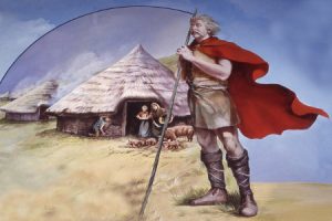
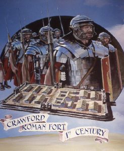
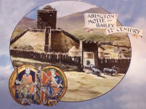
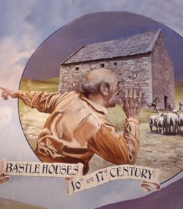
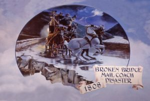
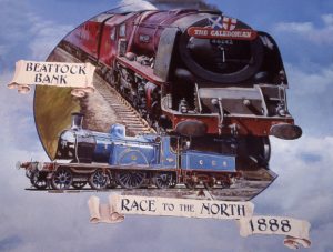
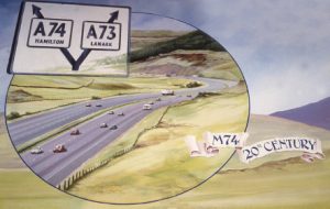


 and the black rock (basalt) protruding from a later intrusion.")


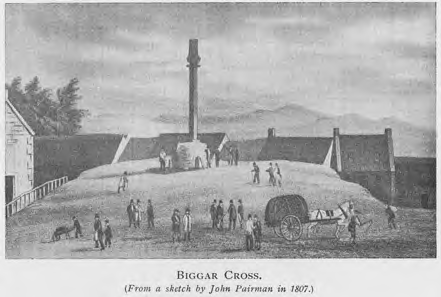


")