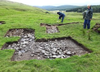
With the Howburn archaeological site now shown to be the oldest open-air site in Scotland, dating to the last phases of the last glacial period, the Devensian Epoch, comes the pressing need to understand the environment these Late Upper Palaeolithic hunters occupied. Two concerns are uppermost: first, an understanding of the geography 12000 calibrated years ago; second, whether these hunters and their prey, be it reindeer or horse, lived in a wooded or open grassland habitat.
Most comparable archaeological sites on the continent are close to standing water, with the interpretation that prey are drawn to a watering-hole. The valley-floor immediately below the archaeological site was cored in February 2009 with a lightweight corer and lake sediments were identified directly beneath the soil and recent alluvium. These clays and silts are laminated, interpreted as varves, the products of seasonally varying glacial melt-water pulses into a lake dammed by an ice-front, a pro-glacial lake. The significance of this discovery is that, although very poorly dated, ice-sheet recession, and thus the draining of what we are calling ‘Lake Howburn’, has always been assumed to be at least 3000 calibrated years earlier than the Howburn hunters were in the valley. They would have looked out over a dry valley.
The pro-glacial lake sediments at Howburn itself can only be dated by peat overlying them in one small unploughed part of the field, and this peat will be much younger than lake drainage. Attention has turned to the downstream end of the valley, at Strathbogie Plantation, below Elsrickle, where the pro-glacial sediments are overlain by younger lake sediments, but demonstrably much older than the peat, and these, hopefully, can be dated.
Seen from Elsrickle, the flat bog at the bottom of the ridge, in front of the plantation, is a kettle-hole. When the valley was dammed by a glacier, a large iceberg drifted away from the glacier snout and beached at this spot. Such blocks of ice, when covered by the sludge in melt-water, can persist for a long time, but will eventually melt. When this happens, what was the iceberg turns into a pond. The Strathbogie kettle-hole should then contain a sediment record from pro-glacial varved clays and silts, through an open-water phase, until fen peat sealed the sediments. This sequence, being continuous, should tell us when the pro-glacial lake was drained
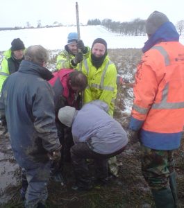
The basal sediments in this kettle-hole have not been reached with lightweight corers: they are at least 13m down! With this in mind, a large and fit team was assembled by Tam Ward on Saturday, 27th February. Amid snow-drifts, this team used a 1.0m long, 6.0cm internal diameter Russian corer to retrieve nearly 8m of sediment, from 2.32 to 8.74m depth. These cores will be analysed over the coming weeks in the laboratories at the University of Stirling by Dr. Lucy Verrill, a post-doctoral research fellow. Analyses will include simple analyses of organic matter content and carbonate content as well as pollen analysis.
These analyses are needed in order to understand the age-range of the lake sediments retrieved. Because the bedrock around the kettle-hole is calcareous sandstone, the lake sediments are in part also calcareous, and this means that we are unlikely to 14C date the stratigraphy. We will use pollen analysis to compare with the patterns seen at other well-examined sites in the Scottish Borders. However, the calcareous sediments that formed in the kettle-hole are valuable because they give us a ‘thermometer’, on the basis that such sediment needs warm water to form. The organic content of the sediment may also be a ‘thermometer’ if warm water is needed to make lake water biologically productive, although lower lake levels bringing the fen-edge nearer the sampling site is a complicating factor here.
These factors came into play immediately, even as we were coring, as suggestions of the age-range of lake sediments can be made from just looking at the sediment as it came out of the ground. The deepest sediments, below 7m depth, are varved clays and silts, and were formed in the pro-glacial lake. These are overlain by highly organic lake mud – a warmer climate? Maybe the warming climate that led to glacier melting? Then this organic mud is accompanied by beautifully delicate, laminated (thinly banded) calcareous mud called marls, here between 525-558cm depth.
These must also be warm-water sediments, probably also seasonal, with marl produced in the summer, organic matter in the winter.
So far this fits with the regional picture of a cold pro-glacial lake replaced by warm-water muds in what is called the Lateglacial Interstadial. This is the period when the Howburn hunters were here. The only open water when the hunters were there was here at Strathbogie. However, the warm-water marls at Strathbogie then pass up above 500cm depth to fen deposits and the peat which eventually covered the entire valley floor. But there’s a problem: after the Lateglacial Interstadial is another very cold phase called the Loch Lomond Stadial, so cold that lakes everywhere in Britain received mud from eroding vegetation-free soils. This phase is not seen so far in the Strathbogie sediments. What this means must wait on the laboratory analyses.
My special thanks for their help in coring goes to Tam and Steven Ward, Alan Rae, Brenda, Peter Dreghorn, Joe Foley, Alick Walkinshaw, Joyce Durham and Jim Ness and farmer Lawson Barrie for transport.


