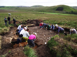
Three new reports are now available for sites 110, 111 and 126. These sites are all similar stone setting sites found during the survey and excavation as part of the Daer Valley project. Suspected to be Bronze Age and potential funerary structures, however there is little evidence to prove this. We discuss this in each of the reports below. All excavation and survey information and images are freely available. Get in touch if you would like more information. A full project report is in progress – in the meantime the interim reports Daer First Results 2011 and Daer Lithics Report are currently available to view.
Site 110 lies on the southern flank of Coom Rig and is at the base of a break of slope leading up hill and just above a less acute break of slope downhill, however the site itself lies on natural sloping ground of about 0.5m. The site was initially seen as boulders and smaller stones disturbed across three furrows, the stones were thought to be from small cairns. Download the PDF (1.5MB) to read more.
The location of this site was first thought to be a group of small cairns dispersed over at least three furrows and disturbed by the forest plough. Stones were evidently disturbed in the furrows but none were visible on the baulks between. The site lies roughly half way down on the southern flank of Coom Rig, and at the base of a break in slope and is on a gentle slope itself, dropping for about a metre from top to bottom in the excavated trench. The area upon which the sit lies is the eastern end of a natural terrace, the western end of the same terrace is occupied by Site No 126. Download the PDF (2.3MB) to read more.
The site was discovered like several others by the presence of large stones lying in the furrow. In this case they were considered unlikely to be the remains of a cairn and indeed they were suspected as being similar in nature to Sites’ 111 and 110, both lying to the east, and to an extent this was shown to be the case. Download the PDF (1.8MB) to read more.
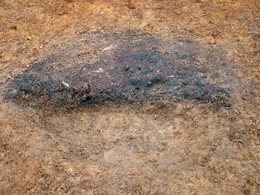
It’s now some time since we last updated the story of the Daer Project. Site No 111 has now been photographed by kite.
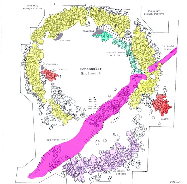
Site 111 from the air
The photos were taken by John and Rosie Wells and Jim Knowles (their website), the leading experts for such work in Scotland. They show the penannular ring enclosure in its entirety and also the relationships with a new road and deep drains, which could easily have cut through the previously invisible site.
We still don’t understand its purpose or for that matter the site just up slope from it (No 110) which although somewhat different in character share the similarity of having no finds to help with interpretation. Each site does have post holes and we have good charcoal from both, so dating should not be a problem.
We believe we can rule out habitation and funerary purposes, and the strong belief is that they are something to do with mortuary practices. We are currently pursuing grant funding from the nearby Wind farm grants scheme in the hope that we can complete the post excavation studies of all of the work up there.
We are engaged in a comprehensive test pitting project on one area of the hill, and results are fantastic, out of about 150 pits so far, we have three further Mesolithic knapping sites, one of which looks like proving the haematite being found is Mesolithic in date. We’ve also discovered another cairn– more likely a stone setting of about 2.5m in diameter.
Depending on any further discoveries by test pitting, the work is starting to draw to a close – but keep an eye on the web as reports on individual excavations will be appearing on a regular basis.
Site No 111, was originally thought to be a group of small cairns cut by the forest plough, however it has turned out to be a most unusual monument and one which still retains its secrets. It now appears to be a penannular enclosure made with boulders up to 0.75m in size but mostly much smaller, kerb stones defined at least part of the interior bank of stones which varies up to about 1.5m wide.
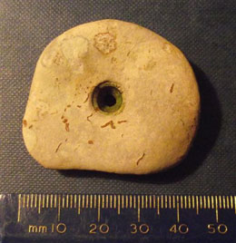
Daer Valley Excavation – Penanular Enclusure drawingA random but nice little ‘hour glass’ perforated greywacke stone , of unknown but early pre historic date, probably an amulet
The interior is almost featureless although a setting of stones formed an arc on the North-east quadrant, where some charcoal has been gleaned and will at least provide a date for the site. There’s been no finds, although a few pieces of chert have been found which are believed to be residual from the Mesolithic period. A second area of stones on the southern lower side appears to have no obvious function and an intriguing gully which runs diagonally through the site is understood to be the result of an old hill drain, although this theory may have complications due to a neat fill of stones. The site is now awaiting photography before further work to unravel its function is commenced.
**Weekend updated – two nice post holes with packing stones were found on Sunday. They were found in the internal area, with no finds these two featured are helpful in deciding what this site could have been – for example we might have two mortuary enclosures with possible excarnation platforms inside.
Another nice, but random find on Sunday. A little ‘hour glass’ perforated greywacke stone, of unknown but early pre historic date, probably an amulet
Here’s the latest reports for the Daer projects – the first is an update to our interim report by Tam and the second is a contribution on lithics from Ian.
Daer First Results report pdf for download
Daer First Results – Tam Ward
We have been working flat out for over a year to salvage as much as possible from the Coom Rig site in Daer valley where the forestry ploughing revealed an incredible and hitherto unknown archaeological landscape and one which has no parallels in the history of our work. Although we had previously surveyed many upstanding sites in the valley and excavated others under threat within the reservoir there, nothing could have prepared us for the large numbers of finds spots now recorded in the present work.
Of the lithic materials recovered in the Daer excavations, it is no surprise that the locally available Radiolarian Chert is by far the most abundant. This paper describes the geology of the Chert and suggests some possible sources for the Daer material.
Fliint is present at Daer in almost all the metre squares excavated – mostly in small numbers – while only rare specimens of pitchstone have been recovered.
This new site (previous update below) is proving to be a lot of hard work.
We have now established that it is an enclosure of around 12m in internal length. It has been kerbed along the inside of the upper bank of stone, so it originally had some form to it. Next weekend we will begin to explore the internal area. So far there have been no finds, no charcoal or burnt stone, therefore a cremation cemetery is maybe unlikely. The internal area slopes down for about a metre, what can this be? All we have done so far is expose the enclosure ‘wall’ on the south, east and part of the north sides, the long axis is running north/south.
We will soon be publishing the initial results of the various excavations at Daer and these will on the web as they are completed – some of the results are staggering, so watch this space.
Latest site for excavation – circular stone enclosure
Volunteers starting off the next site to be excavated.
Here we go again, lots of stones emerging from below the peat at our latest site – and not much else so far!.
What we seem to have this time is a circular enclosure of stones about 15m in diameter and with a with a border of rocks about 1.5m wide. Some of the boulders are big, two men won’t shift them, but most could be carried, once more we can see a big commitment of effort to make this feature, whatever it turns out to be, stones must have been gathered over a fairly large area to make it. Hopefully the answer to it all awaits us in the next few weeks, we cant wait, watch this space.
We’ll be working on this site over the next few weekends. If you are in the area and would like to volunteer use our contact form to get in touch – we’d love to hear from you.
Volunteers starting off the next site to be excavated.
Here we go again, lots of stones emerging from below the peat at our latest site – and not much else so far!.
What we seem to have this time is a circular enclosure of stones about 15 m in diameter and with a with a border of rocks about 1.5m wide. Some of the boulders are big, two men won’t shift them, but most could be carried, once more we can see a big commitment of effort to make this feature, whatever it turns out to be, stones must have been gathered over a fairly large area to make it. Hopefully the answer to it all awaits us in the next few weeks, we cant wait, watch this space.
We’ll be working on this site over the next few weekends. If you are in the area and would like to volunteer use our contact form to get in touch – we’d love to hear from you.
On the 6th August the BBC TV programme Digging for Britain series spent a day with us at Daer. Their theme is the Stone Age and of course we were able to offer them a magnificent opportunity to film a Mesolithic site being excavated.
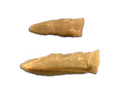
Not only that but we were also able to guarantee that lots of finds would be forthcoming on the day, in fact so much lithic was being recovered it would have appeared the whole thing was being stage managed! The Mesolithic sites at Daer are prolific in both debitage and also tools, and in the case of Site 114, we were finding lots of microliths and also long flint blades with edge wear showing they had been used as blades or knives.
Unusually, the flint ratio to the local chert was very high on this site and a variety of flint types had been brought to the location by the hunters. Of particular interest here is the fact that the site is exclusively Mesolithic in character, and we found numerous pieces of haematite (previously reported), so for certain at this place, the colouring substance is definitely Mesolithic, and although not 100% certain, it is likely that the Haematite found on the ‘transitional’ sites may also be of Mesolithic date.
Stripping out the baulk between furrows
We were lucky to find two small pit features full of charcoal and burnt stone, all of the grit from the residue of the samples taken was completely discoloured by burning, so we are sure that the pits were the product of fires rather than simply having charcoal deposited from some unknown source. The pits lay immediately at the front of a very narrow terrace which immediately dropped down; the trench was about 60 square metres and lay on sloping ground.
The charcoal will allow for radio carbon dating and also species identification, an amazing fact is that we have recovered charcoal from every single excavation location on the project so far, this promises to add substantial data on both the environments through time and the sequence of occupation on the various sites.
The site prepared for filming
Site 114 also produced ‘hot spots’ of lithic concentrations like several other sites on the project, recording lithic to one square metre grids may help specialists to determine actual knapping zones on the sites.
While we were filming on this location yet another Mesolithic site was found only a few metres away; Site 115 may of course be part of the same activity, and this remains to be seen, however, it serves to re-enforce the fact that countless Mesolithic sites must exist in this small area, only a major campaign of test pitting could determine that, as the vast majority of the furrows have not been ploughed below the peat cover. We do not have the people resource to do that and it will be a sad fact that despite trying, and failing to encourage people to come along and help, the true scale of this amazing archaeological landscape will not be realised.
Filming the team. Note the new Clyde Windfarm in the background
We are now abandoning the area where most Mesolithic sites have been found and our next excavation will be downhill from Site 110 where we found an enigmatic building with an adjoining stone setting, the new site appears similar with a possible ring of stones. Site 110 is suspected as possibly having a mortuary function and it may be that the lower site is the cemetery – watch this space
The site lies of the southern flank of Coom Rig and is at the base of a break of slope up hill and just above a less acute break of slope downhill, however the site itself lies on natural sloping ground of about 0.5m. Upon discovery the site was seen as boulders and smaller stones disturbed across three furrows, initially the stones were thought to be from small cairns.
However excavation soon established that the stones were not cairns and formed a more or less single layer for the most part, although the lower side of the site appeared as a slight bank of stones measuring c 2m wide and by no more than 0.5m high, this was later shown to be the result of possible anthropogenic alteration of the sub strata
The general matrix of the site consisted of the following: a turf layer on peat up to 0.4m in maximum depth, this lay directly on the stones of the monument and where they were absent, on the old ground surface (ogs). The ogs was up to 250mm deep but more generally around 100mm and it overlay the entire site, covering an orange coloured natural till. The ogs consisted of a mixture of fragmented shale and small greywacke pebbles, all extremely weathered by leaching below the peat; they lay in a matrix of creamy coloured clayey soil, the clay content being derived from the leached stone in the ogs and the larger stones of the monument. Various cut features; small pits, were dug through the ogs and into the till.
Lying on and slightly within the ogs were the monument stones which had been gathered from the surrounding landscape and which for the most part were flat, but along with some sub angular rocks and boulders, were laid down as a single layer, only in a very few instances were stones seen to overlap and this may have happened since their original laying. The predominance of flat stones may have been a deliberate choice or may simply reflect that such stones are available on the hill side. Only a single boulder on the site could be seen to be natural in its location, it lay beneath and was surrounded by the ogs and the stone lay directly on top of the till.
Charcoal, sometimes in copious quantity lay over but not in the ogs for most of the site. In a hollow arc on the lower southern side of the site and adjacent the stones there, the charcoal was most dense and in one area it included a small quantity of tiny roundwood, which may be heather.
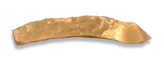
Eight post-holes mark a circular enclosure approximately six metres in diameter. Four forward post-holes represent the position of an entrance porch. Although shape and size suggest a bronze age structure, no Scottish parallels exist
The pits were cut through the ogs and into the till below, stone packers were used in at least six of the eight pits all of which make a near perfect circle of c5m in diameter; the spacing between the pits was uniformly 2m apart. The pits are interpreted as post holes for a circular structure, although whether it was roofed is uncertain. Pits on the east side and outwith the circle appeared to form an entrance and possibly indicate the position of a porch, the double and triple pits here may indicate there were replacement posts inserted. It is also possible that pits F7, F8 and F14 were replacement or reinforcing posts in the circle. A few other pits within the circle have no obvious purpose and some may be natural features, eg F13.
The only finds from this site were a single chert scraper and a clutch of chert debitage, all of uncertain date. The finds therefore offer no clues as to the date of the site, however, the abundance of charcoal which has been collected from various features will eventually be analysed and a radio carbon date will be obtained. We suspect a Bronze Age date but the function of the monument eludes us.
The stone setting appears to have been designated area of activity and has some similarity with other places on the hill we have so far investigated, nothing has been found below these stones which in this case were laid directly on the ogs, their purpose remains enigmatic as does the circular timber structure. A habitation is ruled out on the basis of small size and also lack of diagnostic finds and a burial site is similarly dismissed on the lack of suitable evidence. We wonder if the combination of stone platform (?) and timber building may have a mortuary purpose and, at this stage, if the building was roofed and was burned down to account for all the charcoal, since we found no evidence of a fire place.
We have a similar site just down hill to look at and we are hoping this one will shed some light on this mysterious site. However, currently we are back to the Mesolithic for yet another amazing location which is producing masses of assorted lithic, including numerous microliths and charcoal features are emerging, more of this exciting location soon.
Site 107 a stone pavement aligned East/West along the long axis.
We’ve hade a number of new, if confusing, sites from Daer over the past couple of months that have proved exciting.
One of them – site 107 consisted of a single layer of stones laid edge to edge for the most part of the 8.5m by 2.8m setting, aligned East/West on the long axis and running up a gentle slope. The stones had been gathered from the landscape and were all angular or sub angular and with rounded edges.
Two possible separate settings within the group were evident, the lower one at the East end measured 2.8m by 2.0m, forming an oval shape, and this appeared to be bounded by perimeter boulders with the central area being infilled.
The other apparently distinct setting was at the upper West end, measuring 2.2m by 1.4m, the long axis was aligned with the slope of the ground. This grouping had a mixture of stone sizes and had no obvious design in their layout.
Between the two possible settings the rest of the features appeared as a more ad hoc arrangement with spaces between some stones while others were laid edge to edge. Certainly some disturbance had taken place with the forest plough which removed some stones and damaged others along the line of the furrow which terminated on the feature; however, the disturbance was minimal.
During excavation it became apparent that the feature had been laid on prepared ground, the original soil having been removed and the stones laid directly on to the till (a clayey hill wash with small weathered stones) and lying over the orange coloured gravelly till which is normally encountered on most sites on the project.
Occasional small burnt stones lay below the main stone setting, along with a light and sporadic scatter of charcoal fragments. A slight concentration of small charcoal pieces was sampled.
No artifacts of any type were located below the stones which were mostly removed by excavation and only a few tiny pieces of lithic flakes and a pottery fragment, too small to be diagnostic were found during the cleaning of the stone setting.
The feature was located immediately below a shallow peat cover which indicated it was at least pre historic in origin. Because a soil profile had not developed over the stones it may be that the stones were laid down in the Late Bronze Age, immediately prior to peat growth in the area.
Site 110 – possible enclosed cremation cemetery
To the SE of this site there is an apparently random but slight scatter of burnt stone and charcoal, no explanation for this is obvious. Domestic activity may have accounted for it but again no evidence in the form of artifacts was found. However, it is likely that the stone setting of Site 107 was built over a pre existing scatter of burnt material and that the burnt material there had nothing to do with whatever activity took place at Site 107.
It was obvious that the stones had been gathered from the landscape and that the larger stones must have been dragged from beyond the immediate vicinity. Selection of relatively flat stones seemed deliberate. The site preparation and selection and gathering of stones represented considerable planning and work by the builders.
It seems likely, because of their proximity and other similaritie,s that Site 107 and Site Site 92 (another stone setting which appeared to incorporate a 1m diameter ring of boulders) are associated in time and probably in function. But what that purpose was remains unknown. Burial seems unlikely as the amounts of charcoal would not represent even a token deposit of a cremation, and inhumation would probably have involved a pit of which there was no indication. It therefore seems that the stones were laid for an activity on their surface but in the absence of artifacts or any other evidence apart from the stones themselves, which form a unique site type in the Upper Clyde and Tweed valleys, this feature remains an enigma.
Site 110, initially thought of as an enclosed cremation cemetery, is proving difficult, we suspected this site was funerary due to the abundance of charcoal across the majority of the site, however further excavation it has shown that so far there have been no burials. Sampling has been done for all the charcoal that covers the entire site, this charcoal seems to post date (some) of the stones, no doubt about that.
Site 110 – post holes
At this site we have found a series of post holes at one side of the site near a large boulder which sits above ground level on the site. We have a pair side by side and a triple arrangement near by, these are not burials and must have been structural, two things come to mind
a ring of posts around the site, or
(and this would be incredible) a mortuary structure, a platform for excarnation? it’s a long shot but you never know.
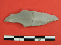
A stone setting and flint scraper, found up the hill from site 110 has now made for another area for excavation.
On the walk back to the access road a few weekend ago we discover another new site (site 113), cut through by the road created by the forestry, we discovered a few sherds of bronze age bucket urn. This pottery, exposed on the road and in the section cut by it, was a typical Bronze age domestic pot. This can really only mean settlement and is another first for Daer Valley. We have excavated more of this site finding more nice bits of bucket urn including rim and base sherds. It initially seems that the road was the main part of the site and we may have lost the majority of it. But only time, and yet more excavation, will tell.
Along with a couple of freshly ploughed fields around the base of the valley – which will be fieldwalked – there proves to be a lot of excavation and discovery to be completed over the summer. We will be working on through the next few months exploring the ever expanding site list which continues to astound us in its complexity and variety. We could certainly do with the additional support, so if you would like to explore the pre-history of the Daer Valley get in touch using our contact form. We’d love to hear from you.
By Torben Bjarke Ballin
Lithic Research, Stirlingshire
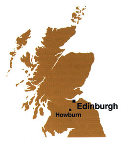
Fig. 1a-b. The location of the site, north-east of Biggar.
BAG are grateful to the Society of Antiquaries of Scotland for permission to reproduce this article by Torben Ballin in the Society’s Newsletter Vol. 23.1
Funding from the Society of Antiquaries of Scotland, and other sources, enabled detailed analysis of the 2009 assemblage from Howburn and the completion of a comprehensive data-base catalogue.
In 2006, Biggar Archaeology Group (BAG), directed by Tam Ward, carried out an excavation at Howburn Farm, near Biggar, South Lanarkshire, and the voluntary group recovered an unusual lithic assemblage. Due to the inclusion of much so-called Yorkshire flint, the c. 1,100 lithics were initially thought to be of a Late Neolithic date, but cursory examination of the finds by the present author and Alan Saville, Senior Curator at National Museums Scotland, revealed the presence of much earlier diagnostic pieces, and they suggested an Early Mesolithic, or even Upper Palaeolithic date.
To increase the number of diagnostic elements, and to clarify site chronology in general, it was proposed to carry out supplementary excavations in the area. Another season’s hard work (2009) by the BAG resulted in the excavation of two new trenches (Trench I 2009 and Trench II), one of which represents an extension of the initial trench (Trench I 2006), whereas the other trench represents exploration of other parts of the terrace. Trench I 2009 yielded c. 1,300 additional lithics, and Trench II c. 2,600. In total, the early prehistoric finds from the terrace at Howburn Farm now numbered c. 5,000 piece
Close scrutiny of the collection by Torben Ballin and Alan Saville revealed a fairly homogeneous assemblage, in terms of raw material preferences and typo-technological elements, and although the finds undoubtedly include artefacts from the Mesolithic and Neolithic periods, the bulk of the assemblage is certainly Upper Palaeolithic. In typological terms, the Upper Palaeolithic material is composed largely of 1) tanged points, supplemented by backed points and fragments; 2) scrapers, many of which are based on regular blades; and 3) burins. In addition there are some truncated pieces and various forms of piercers.
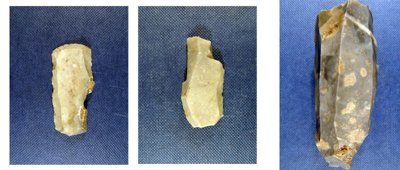
In the Upper Palaeolithic of NW Europe, tanged points are known from several contexts, but the 30 pieces from Howburn clearly belong to the Hamburgian Havelte phase. Havelte points are characterized by having an asymmetrical tang, which was formed mostly by ‘propellar’ retouch (ie, one lateral side retouched from the dorsal face, and the other from the ventral face), and many tangs are associated with a ‘notch-and-spur’ feature to facilitate hafting. The collection includes 70 blade-scrapers, some of which are equipped with a working-edge at either end. The frequently acute scraper-edge of these implements sets the pieces apart from blade-scrapers from later periods. A total of 34 burins define this assemblage as unique in a Scottish context, as for example Scottish Mesolithic sites rarely yield more than a few burins, and the tool type is generally absent from post-Mesolithic locations. Thirty-six truncated pieces probably include various forms of knives as well as fragments of points. A small group of piercing implements include a handful of so-called Zinken (asymmetrical piercers only found in Hamburgian contexts), and equal numbers of traditional piercers and so-called becs (robust Palaeolithic piercers).
Figs 2-4. Typical Hamburgian tanged points (2-3 with ‘notch-and-spur’).Fig. 5-7: A double blade-scraper, a multiple burin, and a cylindrical blade-core
The technological approach followed by the Howburn settlers is distinct, and although single-platform cores are present at the site, opposed-platform technique seems to have been the preferred approach. Most cores are rather squat cylindrical specimens, but there are also several slender cylindrical cores, similar to those found in Hamburgian contexts on the Continent. However, the most diagnostic technological element is the site’s so-called en eperon blades. The en eperon technique provides cores with fine platform faceting, and blades struck off these cores have a notable spur at the proximal end. Although this approach has been noted in connection with Continental Hamburgian sites, it is mainly associated with sites from contemporary Magdalenian and Creswellian industries.
The site includes a number of lithic concentrations, but one is particularly interesting, as it appears to be almost devoid of later intrusive elements. Where most other concentrations include finds in different raw materials, as well as Mesolithic and Neolithic stray finds, the concentration in the southern part of Trench I 2009 almost exclusively consists of flint artefacts, and the diagnostic implements form an oval cluster. It is thought that this concentration may have been formed within a late Hamburgian tent, and there are spatial similarities between this concentration and assumed Hamburgian tent concentrations in southern Denmark.
The presence of Havelte points, and the application of the en eperon technique, both indicate a date at the end of the Hamburgian period, between c. 12,300-11,900 BP. Usually, this period is associated with Late Glacial nomadic reindeer-hunters, which would explain the raw material composition of the assemblage. Most probably, these people followed reindeer herds on their yearly cycle from Scotland, through north-east England, and possibly onto the then dry parts of the North Sea, the ‘Doggerland’, and back, and flint, as well as various forms of chert may have been picked up along the way. However, a deeper understanding of these groups, their material culture, technology, economy and ideology relies on the discovery of further Upper Palaeolithic sites in northern Britain. For now, the settlers from Howburn Farm should first and foremost be celebrated as some of the earliest pioneer settlers in recently deglaciated northern Britain.
The Howburn post-excavation project was sponsored by the Society of Antiquaries of Scotland, Historic Scotland, National Museums Scotland, and the Robert Kiln Trust. Interim reports have appeared in Lithics,British Archaeology, Current Archaeology, and the Oxford Archaeological Journal. The analyses funded by the Society’s grant will form part of the final publication of the 2006-2009 work at Howburn, which is currently in active preparation. The artefact photos in this summary are courtesy of Tam Ward, BAG.
We’ve now completed a few more sites and a new one; no. 104 was only discovered last weekend and we have already excavated 9 square metres of it.
This new site is only a few metres away from site No100 which we started a couple of weeks ago and are still progressing – No 100 has produced chert, flint and pitchstone, and also a couple of nice microliths, the pitchstone means there is a Neolithic aspect to it and the microliths clearly indicate the Mesolithic. The new location – Site 104 – has produced a lot of nice flint, mostly honey coloured and struck from beach pebbles. We know this as there have been lots of pebble fragments with cortex.
Initial thinking is that this site is Neolithic judging by the size of the flint; however we have now found eight microliths from the same area, so maybe it’s another mixed Mesolithic and Neolithic like the nearby Site 100.
Faceted haematite – click for larger view
At No 104 we have found a feature which initially looked like a fireplace, but after closer inspection, it looks more like a cooking pit, with lots of charcoal and burnt stones intermixed. Four stakeholes in a rough line were also excavated and amazingly one still had the carbonised remains of a stake in it! So that will be subject to identification and dating.
Site 100 and 104 may not relate to each other despite their close proximity because chert dominates at No100 and in No104 chert is almost absent.
One of the many highlights so far is the discovery of Haematite, a maroon coloured soft iron ore, which when rubbed gives a reddish/maroon colour. Some pieces are faceted by grinding and have striae showing that they have been used, presumably as a colouring agent. Recently in Orkney, Neolithic stone walling was found to have been coloured by haematite. At Daer, we are uncertain whether our haematite, which is sealed below peat, dates to the Mesolithic or the Neolithic as it comes from sites with both periods represented. Either way, it is a significant discovery.
Faceted haematite – click image for larger view
The same type of haematite was used extensively on post medieval sites such as bastle houses and we have recorded numerous instances of this, we presume it was used as keel on these sites in the 17th and 18th centuries. We have not been able to source the haematite but now we have found it in a pre historic context and in the same general area, we are assuming it must have been gathered from somewhere locally in Upper Clydesdale.
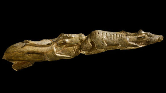
Complementary to our discoveries at Howburn was the inclusion by the BBC, in their ‘A History of the World in 100 Objects’ radio series, of the Swimming Reindeer carved from mammoth tusk in 11,000 BC. It was found at Montastruc, near Toulouse in southern France.
The two reindeer, 20cm long, are a masterpiece of Palaeolithic art captured swimming closely one behind the other, the smaller female in front, the male following. Both have their chins up and their antlers swept back and legs at full stretch. The male displays a very impressive set of antlers and genitals. The female has four teats. Full sets of antlers and well conditioned coats indicate an autumn setting. The piece has been carved by someone who had spent much time watching reindeer swim across rivers.
The carving involved four different technologies. Firstly, the mammoth tusk would have been severed with a chopping tool then the shape of the animal whittled with a stone knife and scraper. Next the piece was polished with powdered iron oxide mixed with water and buffed with chamois leather. Finally the body markings and eyes were incised with a stone engraving tool.
The Palaeolithic cultures of southern France may have had more leisure time and developed more of a need for religion and ritual than our Howburn visitors but the tools described above would all have been available to Howburn Man.
Current Archaeology’s Archaeologist of the Year Award
Biggar Archaeological Group (BAG) is delighted to announce the nomination of its founder – Tam Ward – in the Current Archaeology’s 2011 Archaeologist of the Year.
Run by Current Archaeology magazine, supported by English Heritage, the Awards will be held at the British Museum in London, on 25-27 February.
Tam is recognised as one of the most dedicated amateur archaeologists in Scotland – you can read more about the nomination on the Archaeologist of the year web page. Dedicating over 30 years to the founding and development of the Biggar Archaeological Group, Tam’s commitment and dedication was rewarded with the recent discovery at Howburn Farm (CA 243) proving the earliest Palaeolithic habitation in Scotland.
Tam finds himself in esteemed company with fellow nominees Philip Crummy and Sam Moorhead. Philip Crummy has been the Director of Colchester Archaeological Trust since 1971 and has dedicated his archaeological career to understanding the story of Colchester (Roman Camulodunum).
Sam Moorhead is the National Finds Adviser for the Iron Age and Roman coins in the Department of Portable Antiquities at the British Museum and was involved in the excavation and analysis of the Frome Hoard – the biggest hoard of Roman coins ever found in Britain.
BAG would like to extend our very best wishes to all the nominees in the 3rd Annual Current Archaeology Awards and our special congratulations to Tam – well done!
The work is going well, if a bit slow, but we are continuing to get fantastic results.
Map of excavation area
The current site, Site No 99 is proving very interesting not least because here we are only finding evidence of the Mesolithic, no pitchstone and no pottery. The site is prolific in lithic and as usual it’s mostly chert. Interestingly there isn’t as great a variety of chert at this site, as there is in other locations. However there is a small proportion of flint.
Once again there’s a lack of scrapers, which leads to the opinion that we’re not finding the living zones on these sites, rather the knapping or dumping zones.
Microliths abound and in one discrete area (as yet unfinished) we have found a clutch of cores. There has been 45 microliths recovered so far and the site continues on all sides, in some grids there are up to seven microliths and masses of flakes and other debitage
Curved microlith
The microliths are interesting in one aspect; many appear to have been useless, being very curved or very chunky, these examples may be rejects by the knapper, who may have been a learner at the trade. This may explain why so many appear to have been discarded. However, many others appear to be fine in terms of shape and quality. We’ve seen this same phenomenon on other sites, such as Weston.
Microliths showing retouch
Site 99 may be considered as being conventional in Mesolithic terms, it lies just beside a small burn, and in the same area we have at least another four sites to excavate, all within 100m of each other. The Project will be great for comparing a group of discrete assemblages in a relatively small area. We should eventually get dates from the charcoal, which will all add up to an interesting and unusual piece of work.
So we shall be working away at these sites near the northern end of the hill side for a while, when they’re all complete we shall return to cairns, burnt mounds and other find locations, many of which we’re sure will produce some more surprises.
Up until this week the weather had been relatively kind to us, but with shorter days and the declining weather we shall be struggling through the winter and continuing our excavations in the area. If you would like to come along and lend a hand then please use our contact form the get in touch, we’re in desperate need of more volunteers. As usual we will be working at the weekends but only when the weather permits, so check with us first.
Well, we think we might have finally cracked the search for the Mesolithic to Neolithic transition. We have five sites at Daer where elements of both periods have been found more or less together. The last site, where we got pottery and microliths, seemed to be the best, however the point could still be argued there.
Site No 89, which we had abandoned and returned to, has produced the goods. We found lots of chert, as usual, several nice microliths in the furrow, and a few bits of pitchstone – just enough to tantalise. Now, however, we have found a charcoal patch of ground with Early Neolithic pottery, quite a lot of pitchstone, a fine flint and several chert microliths and chert cores, all wrapped together. Along side these we got some small bits of haematite – one piece which has been facetted by use. This particular find is convincing evidence of haematite being used as a colouring agent in the Meso/Neo period, another first for us and maybe Scotland?
Early Neolithic Potery with rolled rim
These large rim sherds of classic Early Neolithic (EN) carinated bowl was found with other pottery on a site with Mesolithic microliths, the microliths were found in an old ground surface which was adajcent to an area which had been cleared of soil and upon which the Early Neolithic material was found, this is interpreted as the EN people clearing away the Mesolithic soil for their habitation.
The concentration of the finds is extremely good evidence that the same people left everything, and we think they were both hunters and farmers.
Early Neolithic Pottery sherds
The smaller sherds were found on another site but this time within the same context; a discrete patch of charcoal enriched soil which also had a mass of struck chert, cores and microliths from the earlier period, and pitchstone and pottery from the later time. Hazel nut shell was present in the charcoal and this will be radio carbon dated. Interestingly and unusually, the sherd on the rhs has a flat topped rim, most EN pottery has a rolled or rounded rim.
The most recent excavation brought up another concentration of chert debitage, a couple of microliths and lots of core material. As is always the way, just before knocking off for the weekend, a fireplace turns up lying only 0.5m away. Imagining someone knapping by the fire, we’ll be looking for their knapping partner at the other side of the fireplace this weekend! It’s all very exciting
Our next task is to complete all the work at the north end of the hill and continue to explore and find the best sites. From here we’ll work our way back to the start doing cairns and sampling fires and burnt mounds as we go. With a couple of pottery sites to look at there is still a lot to play for. Work will continue throughout the winter as and when weather permits, but we desperately need more help for this important contribution to Scottish archaeology. To do some voluntary archaeology with us – use our contact form to note your interest. We’re normally out every weekend, weather permitting, but get in touch first – that way we can make sure you get access to the site.
Daer will be famous for its Mesolithic sites, but now for the first time we have the Early Neolithic for sure, the map is getting very busy up there and we still have a lot of ground to look at. Our thanks go to all those who have volunteered so far, for being part of this important work.
Do you have some hours spare at the weekend and would like to help explore Scotland’s pre-history. Get in touch and find out how you can help.
I joined the Biggar Archaeological Group (BAG) only in 2003 when the Group was already long-established and, judging from the awards it has received from the BAA for its work, one of most successful amateur groups in the UK.
The origins of the Group date to 1981, when its current leader Tam Ward and two friends began to excavate the ruins of Windgate House [Figs 1a, b].
Fig. 1a: Windgate House – start of excavation and Fig. 1b: Windgate House – consolidated
This building proved to be a bastle house – a farmhouse strengthened to resist attack by cattle reivers. Previously it had been thought that such buildings occurred only in the area closely adjoining, on both sides, the Scottish Border.
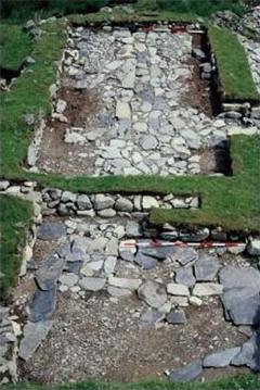
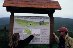
Fig. 2: Glenochar BastleFig. 3: Glenochar – information board
The discovery stimulated a search for further examples and the Clydesdale Bastle Project was born. A further dozen or so bastle houses, some still inhabited, were identified, and, where appropriate, excavated and consolidated.
In the case of the Glenochar Bastle [Fig. 2], in a campaign that lasted 9 years, a number of associated buildings were also excavated and the whole made accessible to the public by means of a Heritage Trail and an information board [Fig. 3].
In 1996, the Bastle Project received the Pitt Rivers Award from the British Archaeological Awards and The Heritage in Britain Award that is sponsored by English Heritage, Cadw and Historic Scotland.
A booklet published by Tam Ward in 1998 [Fig. 4] describes the Glenochar site in detail and provides summary accounts of a further 12 bastle houses in the Clydesdale area.
Fig. 4: A Report of the Clydesdale Bastle Project
Fig. 5: Smithwood Bastle – consolidated.
The Project is on-going. Wintercleuch bastle was not finally consolidated until 2003 and excavation and consolidation of Smithwood Bastle [Fig. 5], in the valley of the Daer Water, continued until 2007. Neither of these sites has been published as yet but an account of the numerous wine bottles recovered at the latter, together with those from Glenochar, is available on the BAG website.
In 1988, with the opening of the Moat Park Heritage Centre at Biggar, the Group took up its present role, although on an informal basis, as the archaeological arm of the Biggar Museum Trust. On behalf of the Trust, the Group has prepared exhibits and educational resources and, in 1990, established The Biggar Young Archaeologists Club [Fig. 6].
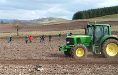
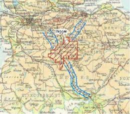
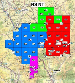
However, the primary thrust of the Group’s activities was and is the investigation, by means of field survey, including an annual fieldwalking exercise [Fig. 7], and excavation, of the archaeology in an area of almost a 1000 km2 that includes Biggar and parts of the catchments of the rivers Clyde and Tweed [Fig. 8]. Thus, the search for bastle houses was transformed into a series of major landscape surveys and field walking exercises
Fig. 6: The Biggar Young Archaeologists Club
Fig. 7: Spring ritual – field-walking at Biggar
The first of these surveys, in the catchment of the Clyde and its tributary, the Daer Water, covered an area of more than 400 sq. km [coloured blue on Fig. 9].
Numerous hitherto unrecognised sites were surveyed and listed in Discovery and Excavation in Scotland for 1991 and 1992 and a detailed report deposited with the RCAHMS. This was followed by a survey, still on-going, of the area around and to the north of Biggar (green). In addition, surveys were carried out in the Manor Valley, in conjunction with the newly established Peebleshire Archaeological Society, and in Upper Tweeddale and in the area around the Megget Reservoir (red). The results of the last two of these were published on the Group’s website in 2004.
Fig. 8: The BAG’s survey area in relation to the main access routes to Central Scotland
Fig. 9: The BAG’s surveys
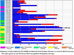
The impact of the surveys is evident from an examination of the records of the RCAHMS and Historic Scotland. A search of Canmore yields 2399 RC-listed sites in the BAG’s area of interest. Of these, 492, or more than 20%, were first recorded by the BAG [Fig. 10]. If ‘historic’ buildings and structures, such as most of the buildings fronting on to Biggar’s main street, are excluded from the RC list, the proportion would be even greater.
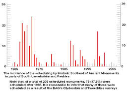
In the same area, Historic Scotland lists 208 Scheduled Ancient Monuments. Fig. 11 shows the dates when these were scheduled. The main peak on the graph without doubt reflects the initial scheduling by Historic Scotland of monuments recorded on the maps of the Ordnance Survey. Unlike the RCAHMS, Historic Scotland give no details of the source of their information. However, 78 of the monuments in the BAG’s area were scheduled by Historic Scotland after 1985. It is reasonable to infer that the scheduling of perhaps most of these, and certainly of 6 bastle houses, is the direct consequence of the surveys and excavations carried out by the Group. Perhaps most importantly, the surveys have located some 21 Mesolithic and Neolithic sites.
In 2006, the Biggar Archaeological Group was named as runner up for The Pitt-Rivers Award for its Daer Valley Project. This was followed in 2008 by the Pitt Rivers award for its Upper Tweeddale Survey.
Fig. 10: The archaeological sites discovered by the BAG’s surveys.Fig. 11: The scheduled sites discovered by the BAG
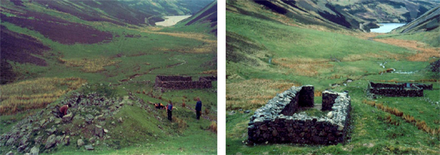
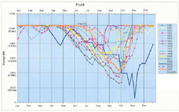
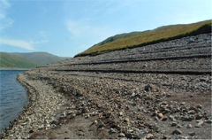
A significant number of the sites discovered by the Group lie within or alongside the 5 reservoirs – Camps, Daer, Fruid, Megget and Tala – that lie within the survey area. In all of these, as typified by Fruid [Fig. 12], the water level regularly falls over the course of the Summer by some 4 to 6m.
This exposes a tract of ground that has been stripped of most of its topsoil [Fig. 13], thereby revealing numerous archaeological features. On-going erosion of these, as the water levels rise and fall, is ample justification for their excavation.
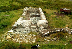
In Camps Reservoir, survey and excavation revealed an archaeological landscape that included 2 Bronze Age funerary sites.
In Fruid Reservoir, the Group excavated two Bronze Age roundhouses [Fig. 14] that were being eroded by wave action.
Fig. 12: The changing water levels in Fruid Reservoir – data supplied by Scottish Water.Fig. 13. Fruid Reservoir, Summer 2003
One of these gave me my find of a lifetime [Fig. 15].
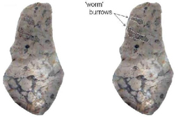
As reported in the BAG’s website, a number of Neolithic structures were excavated in Megget. Daer produced a number of Mesolithic knapping sites, dated at about 8500 B.P. One of these yielded an exotic ‘blue chert’ – actually a silicified limestone [Fig. 16] – that is not known to occur anywhere in mainland Britain except for one tiny flake from Airhouses.
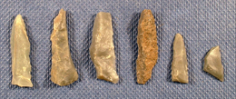
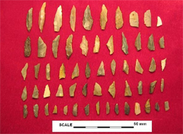
Excavations at other sites in the Daer Valley produced typical microlith-dominated Mesolithic assemblages [Fig. 17].
Fig. 14: Bronze Age roundhouse, Fruid Reservoir.Fig. 15: Bronze Age palstave, Fruid Reservoir
An even more exciting lithic assemblage was found by standard field walking carried out over several years on the lands of Howburn Farm, beside the A702. An excavation [Fig. 18], carried out through the winter of 2005-6 yielded more than 1000 lithic fragments – 583 of chert, 444 of flint.
Diagnostic features of some of the flints [Fig. 19] convinced lithics experts Alan Saville of the NMS and Torben Ballin that, on typological grounds, the assemblage was of late Upper Palaeolithc date. A preliminary account of the material has been published in Lithics. (Saville, A., Ballin, T.B. and Ward, T. 2007).
Fig. 16: Silicified limestone (‘bluestone’) from Mesolithic site at Daer ReservoirFig. 17: Mesolithic flint assemblage, Daer Valley
A number of pits were found during the excavation [Fig. 20] but a C14 analysis of charcoal recovered from one of them gave a date of 200AD. Further excavations on the site, in the Summer of 2009, produced numerous other typical Palaeolithic flint artefacts, as reported on the BAG website.
So far, none of the excavations carried out by the BAG has attracted an award. Excavations are great fun but tend not to earn awards. Instead, it is the identification of hitherto unrecorded archaeological features through landscape survey and fieldwalking and projects that make archaeology accessible to the wider public by way of Heritage Trails, information boards and websites that win prizes.
Fig. 18. Excavating a Palaeolithic site, Howburn 2005.Fig. 19 . Palaeolithic tanged point, Howburn.
Having said that, in the 5 years I’ve been a member, the Group has excavated, wholly or in part, 43 buildings and other features, including one Palaeolithic site, 7 Mesolithic sites – one being a 6000 year-old chert quarry – and 6 Neolithic sites. Almost all were under threat from erosion or from agricultural or forestry operations. Prehistoric sites are especially vunerable as they tend to consist of shallow pits and lithic scatters. I have taken part as a volunteer in professional supervised digs such as the Mediaeval cemetery at Auldhame, the Iron Age houses on Traprain Law and the re-excavation of the Roman Fort at Cramond. I can attest that the BAG digs fully meet the most exacting standards.
Fig. 20: Emptying am Iron Age pit, Howburn 2005.
Not all the sites excavated by the Group are prehistoric. More modern structures, that were gradually disappearing as a result of stone-robbing, include, in addition to bastles, workers’ cottages and farmsteads dating from the 16th to the early 19th C. Such sites tend to produce significant quantities of finds – mostly pottery and glass shards – [Figs 21, 22,] – the processing and cataloguing of which can be time-consuming.
The success of the Group can be attributed in large measure to the dedication, not to say, fanaticism of its leader, Tam Ward, who has spent uncounted hours organising, supervising and recording field surveys and excavations, in the post-excavation processing of finds and soil samples and in the preparation of Reports.
Fig. 21: Sherds from Bellarmine jug. Late 17th Century Fig. 22: Guard from small sword. LoganFig. 25: Boating on Fruid ReservoirFig. 26: Wet-seiving at the Covent ers’ Museum, Biggar.
However, the Group has benefitted greatly by the availability of work and storage space and other facilities, as well as financial support, provided by the Biggar Museums Trust. It is indeed hard to see how an amateur archaeological group can survive without such assets. Archaeological investigations are not cheap, even when staffed by volunteers. Over the years, the BAG has commissioned almost sixty C14 dates at a cost of some £20 000 at today’s prices. And from time to time, there are also fees to specialists. Over the years, the Group has benefitted from the support of numerous private and public sponsors including LADAS, PAS and Historic Scotland.
The results of the work must be made available. There is no more serious crime in archaeology than the failure to publish. Fortunately, digital reports are becoming increasingly acceptable but this means that a website has become a necessity. Through its website [Fig. 24], which in 2006 was commended by the judges of ‘The Mick Aston Presentation Award’, and has been further updated and improved since then, BAG is currently catching up on the publication of its projects.
Conclusions
There are lessons to be learned from the BAG.
Strong, even dictatorial, leadership is essential. In the case of the BAG, this has been provided by Tam Ward – a driven man – prepared to devote uncounted hours to the Group’s activities. It is moot whether the Group will survive when he decides to hang up his trowel.
Landscape surveys with fieldwalking are relatively cheap and win awards. Reservoirs are especially fruitful sources of new sites.
As any structures discovered in reservoirs lie in the zone of active erosion, rescue digs are easily justifiable. Excavation is also justified in the case of sites, such as lithic scatters, that are under threat from aggressive modern farming methods or forestry.
Be sure you can finish what you start. The Glenochar Bastle Project ran for a gruelling 9 years. The Fruid Bronze Age roundhouses took 4 years to excavate in the windows of opportunity afforded by falling water levels. And several tons of soil samples had to be brought back – precariously in a small boat [Fig. 25] – and wet-seived [Fig. 26] for charcoal.
It is vital to make available the results of the work – whether survey or excavation.
It is important to establish links with your local museum and the local and national bodies that have an interest in Scotland’s archaeology.
Secure your funding.
The success of the Biggar Archaeology Group over the past 28 years is due to its adherence to these guidelines.
The project is moving along very nicely and we have some more exciting things to report. We now have four sites where Early Neolithic material has been found in apparent association with the Mesolithic artefacts. Flint scrapers, pitchstone, and pottery have been retrieved along with a flint and a chert leaf arrow. We are wondering if (and hoping that) we have found the elusive transition between the two periods. The evidence is stacking up to say we have.
The Daer valley contains no natural chert, either in situ rock or drift geology, therefore all of the lithic found there has been brought in by the people. We have found every type and colour of local chert along with flint, pitchstone and various other types of chalcedony and mudstone/siltstones. The latter have been brought from Dumfriesshire and may indicate a travel route up the rivers Nith and Annan to connect over into the Daer valley. On two sites we have retrieved dateable charcoal from pits and surface spreads (only a tiny amount of hazel nut shell is represented) and we have managed to detect stake holes, although little of it makes much sense, however, it is early days yet.
Some of the Group pictured at the excavated cremation pit found below a cairn
Continually picking up lithics can be a bit boring, so we have diverted onto some of the many cairns we have found and which have been trashed by the plough. The first produced a pit full of charcoal and this is interpreted as a cremation deposit although no burnt bone was present. The second appeared to be just a pile of stones and this one may simply be the result of pre historic field clearance. We are sure that some of the other cairns will prove to be funerary in function, but most will be field clearance piles.
A typical plough wrecked cairn, this covered the cremation pit
We have now recorded over two hundred find spots on a single hill flank, some are features such as cairns or burnt mounds while some are a single piece of chert or flint, there is no chance of investigating every location so we are targeting those considered most likely to produce the best evidence.
One thing seems to be sure and that is that upland landscapes with recorded archaeological visible sites represent only a tiny aspect of what may lie invisible until disturbed, as in the Daer valley. We still require more help to pull off this exciting work, contact us if you fancy a weekend of discovery.
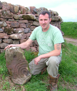
The finder Austen Reid with the cup and ring stone at Dunsyre
While Austin John Reid, a dyker from Peebles was rebuilding drystane dykes on Easton Farm, near Dunsyre in South Lanarkshire in June 2010, he recognised a stone slab decorated with cup and ring marks.
Mr Reid posted a photo of the stone on a web site; The Megalithic Portal, and I was informed of this by one of the local archaeology volunteers. Contact was soon made and the stone was handed in to me for reporting and for the purpose of Treasure Trove consideration, which has been done.
The stone
The stone is pink coloured and is a slab of Old Red Sandstone. It measures overall 600mm long by 330mm wide by 90mm thick
The design consists of a clear but incomplete cup and ring motive and two further cups which form a straight line with the central cup of the main design.
The end cup measures 60mm in diameter by about 12mm deep, but the detail of this side of the stone has been eroded. The central (single) cup is 50mm in diameter by 20mm deep, the gap between the two cups is 50mm.
The main design consists of a cup 45mm in diameter by 20mm deep, it is centrally positioned within four rings, the outer one forming a c150mm radius from the centre of the cup. Each ring is c10mm wide by c8mm deep and about 50% of the rings are missing on one side.
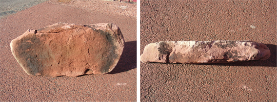
Full decoration on stone and View showing fresh break along edgeView showing staining where exposed on dyke and Worn edge surface on left, fresh surface in middle
The original condition of the carvings can now only be conjectural but they were probably much better defined than they now are.
What is obvious both from the condition of the stone and the organic growth which covered part of it, is that it has been eroded at both ends since its use in a drystane dyke some time in the 19th century. Each end, including the end cup and part of the cup and rings can be seen to have been eroded, while the middle of the stone for about 350mm can be seen to have more fresh surfaces, also the featureless back of the stone is also fresh. This implies that the stone was part of a larger slab and which may have been broken, intentionally or otherwise, for use in the dyke.
Other decorated stones from South Lanarkshire and Borders area
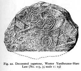
RCAHMS, 1978 Decorated capstone, Wester Yardhouses-Hare Law
This discovery is the first of its type to be found in South Lanarkshire; in fact the nearest examples of cup and ring are from Wigtownshire (Stell 1986) where multiple examples are carved into more intractable greywacke rock than the Dunsyre sandstone. In South Lanarkshire, only two examples of pre-historic rock art have previously been discovered; one of these is fairly local to the present find, being only 8km to the west at Wester Yardhouses Farm, Carnwath. The two carved stones (from Carnwath and Dunsyre) mark the west and east ends of one of Scotland’s most prolific concentrations of pre-historic monuments and sites (RCAHMS, 1978) and which date from the Mesolithic through the Neolithic to Bronze Age periods (Clarke, 1989).
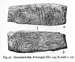
The Wester Yardhouses stone is decorated with spirals and pecked triangles and was found as the capstone of a Bronze Age cist within which a beaker was found. This stone is from the Neolithic period judging by the design and the fact that the stone appeared to have been re-used for a capstone. The other stone was similarly found as a re-used Neolithic decorated stone, again for a Bronze Age cist, and this was at Ferniegair near Hamilton. The Ferniegair stone is carved on its sides with concentric circles, spiral and linear designs, and the suggestion is that this stone was set up as a free standing monument. Therefore the Dunsyre stone remains unique as the only true cup and ring marked stone from the County.
RCAHMS, 1978 Decorate slab, Ferniegair
Nearby in Peeblesshire there are four recorded examples of rock art, only one of which is a cup and ring stone. This has three rings around a cup and was found as a fragment near the Roman fort of Lyne (RCAHMS, 1967/1) and is now in Peebles Museum. The other examples are; the most recent being found as part of the make up of a Bronze Age burial site at Woodend, it consists of part of a design of seven concentric circles pecked into a piece of greywacke rock. On the opposite bank of the River Tweed from Woodend at Drumelzier a stone was found in a similar site to Woodend, this was carved with four sets of double rings and a single ring (RCAHMS, 1967/2). The final stone was recovered from a site near Lamancha (RCAHMS, 1967/3) and is now in the National Museum. This one has multiple examples of double and single rings and also spiral decoration and probably dates to the Neolithic period.
Dating and purpose of rock art
The dating of such rock art can only be done by association with monuments wherein it is included. Instances where cup and ring are found in situ in chambered tombs help with a Neolithic interpretation of date, such examples may be seen in the north east of Scotland at the Clava Cairns near Inverness (Close-Brookes, 1993). Cup and ring marks generally are found on in situ rock faces and excellent examples of these may be seen along the west coast of Scotland. However, it is generally believed that cup and ring decoration is also a feature of the Bronze Age period. The symbolic function of such rock art can only be conjectural and many theories exist.
References
Stell G, Exploring Scotland’s Heritage, Dumfries and Galloway, Royal Commission on the Ancient and Historical Monuments of Scotland. 1986
RCAHMS 1978 Lanarkshire An Inventory of the Prehistoric and Roman Monuments, Royal Commission on the Ancient and Historical Monuments of Scotland. 1978
Clarke A, Corse Law, Carnwath, Lanarkshire: a lithic scatter, Proceedings of the Society of Antiquaries of Scotland. Vol 119 (1989)
RCAHMS 1967/ 1, 2 & 3 Peeblesshire An Inventory of the Ancient Monuments, Royal Commission on the Ancient and Historical Monuments of Scotland. 1967
Close-Brooks J, Exploring Scotland’s Heritage, The Highlands, Royal Commission on the Ancient and Historical Monuments of Scotland. 1993
Developments in understanding the ice age lake sediments from Loch Howburn
by Richard Tipping, 31 July 2010
FIG 1. Coring in the Priest’s Well basin, looking up to Elsrickle, in February 2010
In the last report (Sediment Core Analysis 1), I described the work Lucy Verrill and I were doing in trying to understand the record of environmental change contemporary with the hunter-gatherer camp above the valley floor some 14 000 calendar years ago. We had christened this ‘Lake Howburn’, but with due deference to Tam’s sensibilities, we are rightly calling it ‘Loch Howburn’.
Loch Howburn originally extended from the narrow gorge of the Candy Burn where it falls to Candy Mill to the north east to fill the valley floor directly beneath the archaeological site. There are in fact two lost lochs, because a deeper but smaller loch lies at the foot of the long slope from Elsrickle (Figure 1), which we have called the Priest’s Well basin: the Priest’s Well is a chalybeate spring from which ‘magically’ emerges orange-red water. To complicate matters, both lochs were originally joined – see my last report.
The extent of Loch Howburn
Fig 2. The valley floor that was Loch Howburn and the three possible outflows
By probing beneath the soil of the valley floor with special corers we can record where the sediments of these former lochs were. This is why we know Loch Howburn stretched up-valley to Howburn Farm. Lake sediments on the valley floor are found up to around 45m above sea level (asl). Lake level must have been higher. Lake level is controlled by the altitude of the outflow or the height of something like a glacier blocking the lowest outflow. North east of Howburn Farm the watershed, the col, is around 255m asl but colleagues in the Biggar Museum Trust showed that to the west there are two cols at around 250m asl. These therefore controlled lake level. One outflow passed what is now Cocklaw Farm; the other was in the gap in the hills between Biggarshiels Mains and Greenwood. We have now probed the sediments in both outflows. Lake sediments at the Cocklaw farm outflow have been found up to around 250m asl, showing the lake spread this far west. But no lake sediments have as yet been found in the Biggarshiels gap. They may be absent because the glacier blocked this outflow as well as in the adjacent Candy Burn.
FIG 3. Banded grey sediment in a 1.0m long Russian corer: February 2010
What do the lake sediments look like?
Sediment cores are taken with hand-operated but heavy equipment: it is a team effort. We can distinguish ice age lake sediments from younger ones by several characteristics. They are pale grey rather than mid-brown because there was effectively no biological activity that might produce peat-coloured organic matter. They are high in a mineral called silica from rocks elsewhere in southern Scotland, not local to the lake catchment. They are also often delicately banded because there were marked seasonal contrasts in the supply of sediment from glaciers and hillslopes (Figure 2).
FIG 4. Millimetre and narrower laminae in the oldest lake sediment to have formed in the Priest’s Well basin
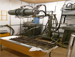
In the laboratory these bands can be seen to have even more detail. Figure 3, for example, shows the thin laminae that formed when the glacier delivered sediment to the lake. The pale brown laminae are of silt-sized particles delivered in the summer months when meltwater streams were bigger; the pale grey laminae are clay-dominated and represent the slow settling-out of mud in winter months when meltwater was frozen. So each pair of grey-brown laminae represents a year in the ‘life’ of this lake. Looking closer, some laminae can be seen to be occasionally thicker: these probably record the variability of weather from year to year. And some laminae are made of sand-rich mud, perhaps pushed into the lake in particularly warm summers when meltwater release was greater. In autumn 2010 an undergraduate at Stirling University, Matt Bradley, will begin the task of measuring the numbers, thicknesses and particle sizes of these laminae to reveal longer-term climatic patterns at the end of the last major ice age, from high-resolution photos, from microscope slides where even more detail is revealed and from X-rays (Figure 4) that might tell us about hidden details.
FIG 5. X-raying sediment cores at the National Museum of Scotland laboratory
The lake sediment in the Priest’s Well basin holds much more information, though. In the warm period we live in, called the Holocene Epoch, the sediment in the lake was no longer supplied by glaciers. Soils on the volcanic rock around the basin supplied calcium carbonate to the lake in a process called leaching. This is a form of chalk, and it’s a creamy-white colour. Soils also began to accumulate organic matter from decaying plants, and in the lake itself plants and animals grew and died to form dark brown layers. All these processes have led to lake sediment that is also laminated, probably also controlled by the seasons (Figure 5). We have a lot of work to do over the next few months in fully understanding these sediments.
FIG 6. Laminated calcium carbonate / organic mud sediment in the early part of the Holocene Epoch
So how old is Loch Howburn?
FIG 7. Moss stems scattered in pale grey mud.
The evidence for Loch Howburn being formed by a glacier is impressive: we have a lake chemistry dominated by silica sediment from the region; we have great thicknesses of sediment from a source rich in mud; we have laminated sediment that looks at present to be glacier-fed. Loch Howburn also seems to have drained quickly, and the lake vanished with this emptying. It was at this time that the Priest’s Well basin emerged as the only open water. But when was the glacier in the Candy Burn, and the Biggarshiels gap? Was Loch Howburn open water when hunter-gatherers watched for reindeer and wild horse? We have always assumed not because deglaciation is thought to have been complete long before 14 000 calendar years ago, maybe 16 to 17 000 calendar years ago.
But we have submitted samples from sediment that formed in Loch Howburn towards the end of its ‘life’. The material dated is unusual – rather than date the mud itself, which is fraught with difficulties, we concentrated tiny moss stems preserved in the mud. Figure 6 shows these scattered throughout lake mud but they also form distinct mats. These stems still have tiny leaves attached, so they are thought to have been preserved where they grew, with mats of stems perhaps representing growth in particularly warm summers. Two samples tell us that Loch Howburn was still filling the valley floor between 12 and 13 000 calendar years ago, after the hunter-gatherer camp. This is a major surprise, one that would baffle scientists researching deglaciation, and our first instinct is to think the radiocarbon dates don’t make sense. However, it is not yet clear why this should be given the careful selection of moss stems.
To sort this puzzle out, scientists from Royal Holloway College in London will look for traces of ash-falls from volcanic eruptions in Iceland and the continent, and we’ll ask for more radiocarbon dates. Its still too early to run away with the idea that Loch Howburn was actually as young as it appears.
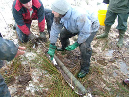
An update on the completion of the first of our sites at Daer.
Extensive fieldwalking of an area of new forest that had been ploughed in readiness for replanting revealed a number of concentrations of lithic and other finds. One of these, Site 86, was chosen as the first to be excavated because of the discovery of a round and a long end scraper, both in flint, lying beside each other in the furrow. In addition a large quantity of the local chert, that included some microliths, was present. Evidently there were Neolithic and Mesolithic components to the site and this has now been confirmed by the recovery of fragments of Arran pitchstone and a few very small scraps of diagnostic Early Neolithic pottery.
Stratigraphy of the site
The latest deposits at Site 86 consist of turf lying on a layer of peat. At a depth of up to 0.4m, the peat rests on a severely leached soil containing stones up to c.200mm long but more commonly around 100mm or less. The stones of all sizes are affected by leaching due to acidity of the groundwater – the normally hard greywacke being softened to the point where its surface can easily be scratched by the fingernail.
The soil, at a depth of around 75mm, rests on glacial till. Above and below this contact there is generally a development of iron pan. Lithic materials and charcoal found in the zone affected by the iron pan are discoloured by it and in the case of the charcoal some mineralisation has occurred. The majority of the lithic material occurs in the upper half of the soil layer, commonly being found below stones. A few lithic fragments, as well as leached stones and charcoal, are however present in the basal 50mm of the peat which has intermixed with the upper levels of the original soil.
Finds from a single square metre, including 46 microliths or parts of them, broken microliths are often found.
Finds from a single square metre, including 46 microliths or parts of them, broken microliths are often found. Only pieces showing re touch are classed as microliths. The debitage probably indicates knapping zones, but dumping is not ruled out.
The lithic finds
The range of lithic materials present is unusually large and includes two types that are new to us. These are a grey chert and a green coloured stone which does not appear to be chert. So far, microliths of chert and flint have been recovered, mostly of the local chert but including some nice examples in brown chert, which is more unusual. Cores, mostly amorphous, are abundant.
The micro-debitage from Site 86 clearly indicates the range of lithic types being reduced. Blue/grey chert is dominant, with various colours of flint also being worked. Brown and grey varieties of chert are also present as well as chalcedony, possibly agate.
Neither the fieldwalking nor the excavation has so far produced a single scraper attributable to the Mesolithic period. This strongly suggests that we are not dealing with areas which at that time were used for processing and cooking animal carcasses. Instead, we most likely have a knapping area with at least two preferred sites indicated by concentrations of lithic materials, especially micro debitage.
Burnt stones
Burnt stones occur over the site. Their discolouration is less pronounced than usual as a result of leaching by fluids from the peat that overlies the site. At several locations, stones were observed that had only their uppermost surfaces reddened. It is inferred that these stones were still in the ground when burnt by the fire.
In addition, small greywacke pebbles, discoloured pink by heating, that were recovered in the residues obtained by wet-sieving, clearly show that widespread burning of the ground had taken place.
Charcoal features will give environmental information and dating of the site.
Features and charcoal
It is unlikely that we will find stone features other than camp fireplaces, either formal or informal. There is, however, an overall spread of charcoal fragments within the excavated area, including at the interface of the former soil with the overlying peat. A number of discrete shallow charcoal-enriched features have been found. These may be the basal parts of pits – possibly for post or stakes. Good identifiable and dateable charcoal has been recovered from soil samples by sieving and, in two areas, small fragments of hazel nut shell were also retrieved.
Preliminary conclusions
The Mesolithic (and possibly Neolithic) lithic materials and charcoal were laid over a soil and vegetation profile which probably was up to 0.3m in depth. Throughout this probably brown forest soil were stones of various sizes but generally small ones. Fireplaces or burning occurred over the ground, discolouring the stones and gravel contained in soil that had been in contact with heat. Charcoal from fires was dispersed on the surface of the ground.
The landscape was finally abandoned at the end of the Bronze Age c.3000 years ago when a significant climatic deterioration occurred. The ground became cold and wet causing moss to grow and ultimately form a bed of peat. This process continues at the present time.
When the peat layer was established, the resulting acidification of the ground water caused the stones within the former soils to weather due to leaching. The organic content of the former soil has also been dissolved out leaving only its mineral component thereby reducing its thickness. The clay from the leached rock and the soil now tends to cement the surviving soil into a compact mass. Iron compounds leached by the oxidising fluids were deposited as iron pan at the contact of the soil with the underlying glacial till. The overall thickness of the soil profile has been reduced but the ground surface has probably risen somewhat as a consequence of the growth of peat.
Post-excavation processing
Lithic materials have been cleaned, listed and re bagged and hand processing of soil samples is being done, all of this is on file. The charcoal thereby recovered is now sorted ready for further analysis. The location of find places so far discovered have been plotted on to maps permitting an overview of the result of the fieldwalking exercise.
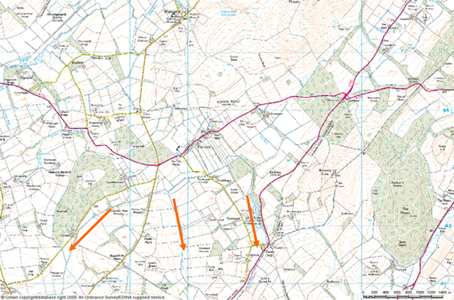
Map showing access from A702
The site
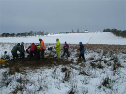
The site is situated within the forestry area of the Daer Valley. The road access is basic and a bit rough, there are locked gates to deter unauthorised access. It’s essential that you contact us to let us know if you are planning on coming along. This helps with all the administration and legal requirements as well. Do this by using the contact form and we will make sure that, if you are making your own way, that the road is open.
A point to note is that there are no facilities provided at this excavation site and it is very exposed– so make sure you get in touch to find out what you need to bring and get information on what is expected.
In the spring of 2023 the members of the Biggar Archaeology Group with the support of Peeblesshire Archaeological Society and Scottish Borders Council surveyed...