
An update on the completion of the first of our sites at Daer.
Extensive fieldwalking of an area of new forest that had been ploughed in readiness for replanting revealed a number of concentrations of lithic and other finds. One of these, Site 86, was chosen as the first to be excavated because of the discovery of a round and a long end scraper, both in flint, lying beside each other in the furrow. In addition a large quantity of the local chert, that included some microliths, was present. Evidently there were Neolithic and Mesolithic components to the site and this has now been confirmed by the recovery of fragments of Arran pitchstone and a few very small scraps of diagnostic Early Neolithic pottery.
Stratigraphy of the site
The latest deposits at Site 86 consist of turf lying on a layer of peat. At a depth of up to 0.4m, the peat rests on a severely leached soil containing stones up to c.200mm long but more commonly around 100mm or less. The stones of all sizes are affected by leaching due to acidity of the groundwater – the normally hard greywacke being softened to the point where its surface can easily be scratched by the fingernail.
The soil, at a depth of around 75mm, rests on glacial till. Above and below this contact there is generally a development of iron pan. Lithic materials and charcoal found in the zone affected by the iron pan are discoloured by it and in the case of the charcoal some mineralisation has occurred. The majority of the lithic material occurs in the upper half of the soil layer, commonly being found below stones. A few lithic fragments, as well as leached stones and charcoal, are however present in the basal 50mm of the peat which has intermixed with the upper levels of the original soil.

Finds from a single square metre, including 46 microliths or parts of them, broken microliths are often found. Only pieces showing re touch are classed as microliths. The debitage probably indicates knapping zones, but dumping is not ruled out.
The lithic finds
The range of lithic materials present is unusually large and includes two types that are new to us. These are a grey chert and a green coloured stone which does not appear to be chert. So far, microliths of chert and flint have been recovered, mostly of the local chert but including some nice examples in brown chert, which is more unusual. Cores, mostly amorphous, are abundant.
The micro-debitage from Site 86 clearly indicates the range of lithic types being reduced. Blue/grey chert is dominant, with various colours of flint also being worked. Brown and grey varieties of chert are also present as well as chalcedony, possibly agate.
Neither the fieldwalking nor the excavation has so far produced a single scraper attributable to the Mesolithic period. This strongly suggests that we are not dealing with areas which at that time were used for processing and cooking animal carcasses. Instead, we most likely have a knapping area with at least two preferred sites indicated by concentrations of lithic materials, especially micro debitage.
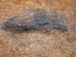
Burnt stones
Burnt stones occur over the site. Their discolouration is less pronounced than usual as a result of leaching by fluids from the peat that overlies the site. At several locations, stones were observed that had only their uppermost surfaces reddened. It is inferred that these stones were still in the ground when burnt by the fire.
In addition, small greywacke pebbles, discoloured pink by heating, that were recovered in the residues obtained by wet-sieving, clearly show that widespread burning of the ground had taken place.
Features and charcoal
It is unlikely that we will find stone features other than camp fireplaces, either formal or informal. There is, however, an overall spread of charcoal fragments within the excavated area, including at the interface of the former soil with the overlying peat. A number of discrete shallow charcoal-enriched features have been found. These may be the basal parts of pits – possibly for post or stakes. Good identifiable and dateable charcoal has been recovered from soil samples by sieving and, in two areas, small fragments of hazel nut shell were also retrieved.
Preliminary conclusions
The Mesolithic (and possibly Neolithic) lithic materials and charcoal were laid over a soil and vegetation profile which probably was up to 0.3m in depth. Throughout this probably brown forest soil were stones of various sizes but generally small ones. Fireplaces or burning occurred over the ground, discolouring the stones and gravel contained in soil that had been in contact with heat. Charcoal from fires was dispersed on the surface of the ground.
The landscape was finally abandoned at the end of the Bronze Age c.3000 years ago when a significant climatic deterioration occurred. The ground became cold and wet causing moss to grow and ultimately form a bed of peat. This process continues at the present time.
When the peat layer was established, the resulting acidification of the ground water caused the stones within the former soils to weather due to leaching. The organic content of the former soil has also been dissolved out leaving only its mineral component thereby reducing its thickness. The clay from the leached rock and the soil now tends to cement the surviving soil into a compact mass. Iron compounds leached by the oxidising fluids were deposited as iron pan at the contact of the soil with the underlying glacial till. The overall thickness of the soil profile has been reduced but the ground surface has probably risen somewhat as a consequence of the growth of peat.
Post-excavation processing
Lithic materials have been cleaned, listed and re bagged and hand processing of soil samples is being done, all of this is on file. The charcoal thereby recovered is now sorted ready for further analysis. The location of find places so far discovered have been plotted on to maps permitting an overview of the result of the fieldwalking exercise.

The site
The site is situated within the forestry area of the Daer Valley. The road access is basic and a bit rough, there are locked gates to deter unauthorised access. It’s essential that you contact us to let us know if you are planning on coming along. This helps with all the administration and legal requirements as well. Do this by using the contact form and we will make sure that, if you are making your own way, that the road is open.
A point to note is that there are no facilities provided at this excavation site and it is very exposed– so make sure you get in touch to find out what you need to bring and get information on what is expected.


