Wildshaw Burn Stone Circle
The monument consists of 23 stones arranged in an almost perfect ellipse. Its long axis, 52m in length, is aligned NNE-SSW; the short axis is 42m long.
The circle [NS 8820 2716] lies between the new M74 motorway and the old A74 road. It is listed as site NS82NE 11 by the RCAHMS. It was discovered in 1990 in the course of an archaelogical survey by the Group of the land earmarked for the upgrading of the A74 Trunk road to motorway standard
We announced the discovery of the site with some fanfare and the outcome was that Glasgow University Archaeology Research Division (GUARD) were commissioned by Historic Scotland to check out our survey result. Subsequently, the writer was employed for eighteen months as the Archaeological Project Officer for the M74 upgrade work in Clydesdale. This post was funded jointly by the local and regional authorities, the road contractors and Historic Scotland.
The monument is on a terrace on the E side of Wildshaw Burn at about 285m OD. The site is on a SW-facing slope and has good visibility in all directions except to the NE where the ground rises gently from it. The stone setting is elliptical measuring 52m by 42m, the long axis being almost on a NS alignment. Thirteen stones were visible on the day of discovery and a further ten were located by probing. These were cleared of about 150mm of moss and peat in order to record them. Peat had accumulated to an average depth of 0.3m over the site.

It is estimated that the complete monument would have had 40 stones at an average distance from each other of 3m. They vary in length from 0.9m to 1.7m. Of the 23 stones present, only two appear to be set in the ground and these are of no great height. The rest lay on the ground and there is no evidence that they were ever set in an upright position. This suggests two possibilities: either the monument was never completed or it was destroyed in antiquity.
The source of the stone has been established as the nearby outcrop of an igneous dyke, uphill from the circle. All the stone is from this source and they are of random shape and size. A small outlying earth-fast stone, 30m to the NE, may have no significance but a recumbent stone measuring 1.6m by 1m lying 260m to the NW may be relevant to the site. T Ward 1990
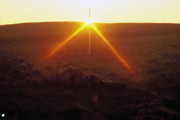
Since its discovery, and after eight years of trying, we have witnessed and filmed midwinter sunrise and sunset, and the same events at the equinoxes. In 1992 midwinter sunrise was observed to take place on an alignment over stone numbers 20 and 10. The first flash of the rising sun is seen exactly in the crossover point between the hills of Craighead and Blackhill, to the SE of the circle. Further detailed survey of the position of the sun relative to this monument has been carried out in an attempt to identify any solar or lunar sight lines from the circle.
In 1995, midsummer sunset was observed to take place on an accurate alignment over stone numbers 10 and 19. The horizon at the point where the sun set had no obvious features. The viewpoint for the midsummer sunrise was at stone 16. The rising sun appeared between stones 5 and 6, again on a featureless horizon.
All these events, except for the midsummer sunrise, make very convincing alignments in relation to pairs of stones within the monument.
NS 8820 2716 In 1992 midwinter sunrise was observed to take place on an alignment over stone numbers 20 and 10. The first flash of the rising sun is seen exactly in the crossover point between the hills of Craighead and Blackhill, to the SE of the circle. Further detailed survey of the position of the sun realative to this monument has been carried out in order to predict any solar or lunar sight lines from the circle. T Ward 1993.
NS 8820 2716 In 1995, midsummer sunset was observed to take place on an accurate alignment over stone numbers 10 and 19 (Ward 1992). The horizon of the sunset is featureless. Midsummer sunrise was observed to take place from stone 16, the rising sun appeared between stones 5 and 6, again on a featureless horizon. T Ward 1995.
Related reports
- Wildshaw Burn Stone Circle and Black Mount Hill Alignments | 738KB
- Wildshaw Burn Stone Circle and Black Mount Hill Alignments | October 2012 | 2.76MB |
Books and References
Ward, T (1990c) \\’Survey: Clydesdale A74 and M74 road development routes\\’, Discovery Excav. Scot. 37-8
Ward, T(1992a) Upper Clydesdale through the ages: the M74 project (archaeology): the Clydesdale experience, [Biggar] Held at RCAHMS D.11.5.WAR
Ward, T (1993j) \\’Wildshaw Burn stone circle (Crawfordjohn parish): circle, observation\\’, >Discovery Excav. Scot. 89
Ward, T (1995k) \\’Wildshaw Burn Stone Circle (Crawfordjohn parish), circle, observation\\’, Discovery Excav. Scot. 87


